Upper Dolpo to Mustang
03 Oct 1 Fly from Kathmandu (1400 m) to Nepalgunj (150 m), the largest city in western Nepal, the heart of the Terai, near the Indian border. Overnight in "Siddhartha Hotel".
04 Oct 2 Fly from Nepalgunj (150 m) to Juphal (2470 m) and from there walk to Dunai (2100 m).
Flight to a small mountain airstrip which gives access to the Dolpo region (flight is subject to weather conditions and operations). Meet guides and sirdar and walk to Dunai, mostly downhill. Lunch and overnight camp at "The Blue Sheep Inn" at the Southeastern end of Dunai.
3:00 h walk, +165/-535 m ascent/descent.
05 Oct 3 Walk from Dunai (2100 m) to Sangta (2460 m).
Walk upstream along the Thuli Bheri Khola and then head North along one of its tributaries, the Suli Gad or Phoksundo Khola. The path rises gradually along the valley through crops and forest (lunch break along the way) until we reach Sangta for tea and overnight camp.
2:40 + 4:00 h walk, +700/-340 m ascent/descent.
06 Oct 4 Walk from Sangta (2460 m) to Chunuwar/Amchi Hospital (3130 m).
The path runs along the Suli Gad still mainly in the forest. Watch out for wild monkeys on the opposite side of the valley. Lunch break along the way. Pass the junction with the Pungma Khola and a boarding school. Camp just past the solar panels of Amchi Hospital. Overnight camp.
4:00 + 3:30 h walk, +1070/-400 m ascent/descent.
07 Oct 5 Walk from Chunuwar/Amchi Hospital (3130 m) to Ringmo (3630 m).
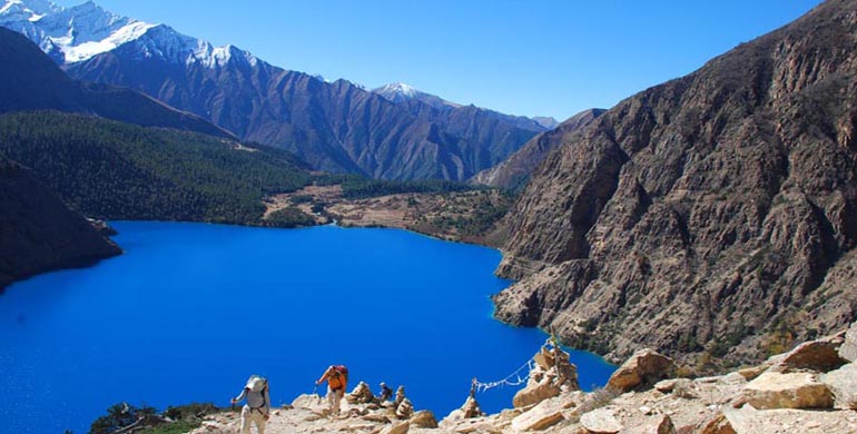
From the village the path rises up the hillside. We pass some pastures and soon discover Palmo, a winter village of the residents of Ringmo. From here the path steepens until we reach a viewing pavillion from where the beautiful Phoksundo waterfall is visible (300 m high, one of the highest of Nepal). From here the path mainly descends through various levels of vegetation towards the village of Ringmo whose houses stand near a forest of pine and juniper trees on the banks of Phoksundo lake. Lunch and our overnight camp will be above the lake. Have the afternoon for rest and exploration of the area - visits to the Bönpo monastery on the lake shore, the village or harvest activities in the surrounding fields.
3:40 h walk, +680/-180 m ascent/descent.
08 Oct 6 Walk from Ringmo (3630 m) up to a high-point of 4080 m to Upper Phoksundo Khola camp (3720 m).
From here we enter the Upper Dolpo area and leave the standard trekking permit area. The path runs along the West side of the magnificent turquoise lake, first along its banks but then quickly rising narrowly up the mountainside. There are many ascents and descents, always offering fantastic views of the lake and surrounding mountains, before we reach the lake's Northern end with a final descent through a silver birch forest and our lunch break. From here the path rises only very gently as it follows the Upper Phoksundo Khola. We have to cross the river once. The camp is further up the valley, overlooked by the Kanjiroba Himal mountain range in the West.
4:00 + 2:00 h walk, +810/-720 m ascent/descent.
09 Oct 7
Walk from Upper Phoksundo Khola camp (3720 m) to Ganda La high camp (4650 m).
We follow the Upper Phoksundo Khola for a short while before turning North-east into the narrow gorge of the Tuk Kyaksa Khola. We have to cross this stream many times before the gorge widens and the gradient eases a little. Packed lunch at a convenient time and location. A long way further up the valley we reach our high camp and have the afternoon for rest and acclimatization.
4:20 + 1:20 h walk, +1050/-120 m ascent/descent.
10 Oct 8 Walk from Ganda La high camp (4650 m) across Ganda La (5360 m) to Shey Gompa (4370m).
It should take about 3:30 hours to the pass: cairns and prayer flags greet us. We descend slowly, eventually following the river. Packed lunch at a convenient time. Later, we reach Shey Gompa, made famous by the stories of David Snellgrove and Peter Matthiessen (The Snow Leopard). We will camp below the monastery at 4370 m. Time permitting, by late afternoon we visit Tsakhang, the hermitage monastery high up in the mountains (2 h hiking).
Shey Gompa was founded, say the Dolpo-Pa, by a great yogi, Drutob Yeshe Senge, who arrived here on a leopard wheel. During his meditations he built a crystal chorten near a small mountain lake. Shey's name comes from elsewhere "shel" means "crystal" in Tibetan. The famous "Crystal Mountain" is a white pyramid sacred throughout Dolpo. The small karma-kagyupa monastery is busy at certain times of the year in late spring. It is the seat of a festival bringing together all of Dolpo at which the pilgrims make a ritual circumnavigation of Crystal Mountain. The monks have banned hunting and so many animals roam the valley of Shey, including the snow leopard.
4:50 + 1:50 h walk, +800/-1080 m ascent/descent.
11 Oct 9 Walk from Shey Gompa (4370m) across Namkung La (5114 m) to Namkung (4410 m).
We leave Shey Gompa heading East along a wide valley, the path rising slowly at first but steepening just before reaching Namkung La, about 4:30 h walk. From here there are exceptional views of the high plateaus and peaks of Tibet in the North as well as of Kanjiroba Himal in the South-west where we camped just three days ago. We descend quickly (packed lunch stop along the way) to set up camp above Namkung kagyupa monastery.
5:00 + 1:30 h walk, +970/-930 m ascent/descent.
12 Oct 10 Walk from Namkung (4410 m) across Saldang La (4580 m) to Saldang (4085 m).
A short day. From Namkung we follow the North side of the valley, sometimes on exposed paths, rising slowly until we reach today's high point at Saldang La. From here we descend steeply towards Saldang village with typical Dolpo-pa houses scattered amongst the terraced hill sides. In the afternoon there is time to stroll through the village or visit the local school. Lunch and overnight camp.
3:30 h walk, +470/-795 m ascent/descent.
13 Oct 11 Walk from Saldang (4085 m) across Khomas La (4645 m) to Khomas (4230 m).
We drop a few hundred metres to the Nagon Khola, cross the stream and ascend the steep path on the East side of the valley. After crossing Khomas La we descend, steeply in places, to Khomas. The afternoon is free for exploring the village and monastery. Lunch and overnight camp
5:30 h walk, +880/-735 m ascent/descent.
14 Oct 12 Walk from Khomas (4230 m) across Shimen La (4370 m) to Shimen (3950 m).
A short day. Again, we descend into a river valley, the Koran Khola, cross the stream on a small bridge, before rising up the other side and across another pass. From here it is not far down to Shimen village in the Panjyan Khola valley. The afternoon is available to explore the village and surrounding fields. Lunch and overnight camp.
3:30 h walk, +350/-630 m ascent/descent.
15 Oct 13 Walk from Shimen (3950 m) to Tinjey (4195 m).
We walk upstream along the river valley, often high above the valley base. Packed lunch along the way. We pass through some deserted summer villages before reaching Tinjey. Across the river we set up camp next to tomorrow's path to the South. Overnight camp.
3:30 + 2:00 h walk, +575/-330 m ascent/descent.
16 Oct 14 Walk from Tinjey (4195 m) to Chhoila La high camp/Larja (4710 m).
A long day across gently rising ground. From Tinjey we first walk South along the Panjyan Khola. Where the river divides, we ford its Western tributary, Sulun Khola, and continue along its shore, fording twice some of its tributaries. Packed lunch along the way. We may pass herds of goats and yaks as well as signs of temporary settlements. We camp in a flat area below the Chhoila La for the night.
4:40 + 2:20 h walk, +810/-295 m ascent/descent.
17 Oct 15 Walk from Chhoila La high camp/Larja (4710 m) across Chhoila La (5060 m) to Dho Tarap (4090 m).
From the camp it is a steep climb straight up the hillside to Chhoila La. From here great views can be had of the surrounding mountains. We descend along the Chhoila Khola into the wide valley of the Thakchu Khola that we follow to the village of Dho Tarap. Packed lunch along the way. This is the most populated area of the Dolpo region: Tok Kyu or Taksi encompasses the villages built on both sides of the Tarap Chu, Dho those at the confluence of the Tarap Chu and Dhoro. Buddhist temples, shrines and Bönpos line the two valleys, the women wear beautiful dresses and in autumn time harvest activities can be seen everywhere. We have now left the area of Upper Dolpo and are back in the Lower Dolpo region. Overnight camp.
4:30 + 1:00 h walk, +500/-1120 m ascent/descent.
18 Oct 16 Walk from Dho Tarap (4090 m) to Charku La high camp (4800 m).
We head East once again, rising slowly, following the river valley of the Tahari Khola. We pass Dhoro Gompa, under restoration, but eventually leave all human habitation behind us to share the landscape only with marmots and blue sheep. The ground steepens as the gorge narrows and we reach our high altitude overnight camp. Enjoy the late afternoon sunshine in this West-facing location.
4:20 h walk, +840/-130 m ascent/descent.
19 Oct 17 Walk from Charku La high camp (4800 m) across Charku La (5477 m) down to Lakkyan Khola (4826 m) across Chharka La (5045 m) to Chharka (4305 m).
From the camp it is a steep ascent to the pass through rock-strewn slopes. From the pass there are magnificent views from Kanjiroba Himal in the West to mountains above Dunai in the Southwest and Dhaulagiri III and V in the South. We descend gently into the next valley but contour around towards the Southeast instead of descending all the way to the river junction. Packed lunch along the way. We then join the wide Myantokti Khola valley until we reach our second pass, Chharka La. From here there is a long descent and trek high above the valley base towards Chharka. Overnight camp.
4:30 + 5:50 h walk, +1150/-1645 m ascent/descent.
[extended day to compensate for muleteers' mistakes]
20 Oct 18 Walk from Chharka (4305 m) to Thasan Khola high camp (4780 m).
Take some time in the morning to explore the unusual fortress-like architecture of the village. We cross the river on a suspension bridge and walk upstream towards the South-east. We cross the river again and continue on the other side high above the Thasan Khola river. Packed lunch along the way. The valley sometimes narrows to a gorge then widens again. At one of the wide areas we stop for our overnight camp.
3:50 + 3:00 h walk, +900/-425 m ascent/descent.
21 Oct 19 Walk from Thasan Khola high camp (4780 m) across Niwal La (5190 m) and Ghok La (5585 m) and down to Ghaldan Ghuldun Khola camp (4400 m).
It is a very gentle rise along the river bank of the Thasan Khola, so it should not take long to reach the very flat first pass, Niwal La. From here the path steepens up a slope towards the East before we reach the second pass, Ghok La. Packed lunch along the way. There are again magnificent views of the near and far mountain ranges. There is now a steep descent across mostly consolidated scree slopes with occasional low passes to cross until we reach our overnight camp on one of the few flat spots in this steep mountain area.
5:30 + 3:00 h walk, +930/-1310 m ascent/descent.
22 Oct 20 Walk from Ghaldan Ghuldun Khola camp (4400 m) to Sangda summer village (3830 m).
We descend to the Kyalunpa Khola river, cross a suspension bridge at 3900 m and re-ascend on the South-side of the river. The path drops and rises as it meanders in and out of side gorges. Eventually we reach buckwheat fields and the summer village of Sangda (there are two villages on each side of the valley, one for winter and one for summer). Lunch and overnight camp.
4:50 h walk, +550/-1120 m ascent/descent.
23 Oct 21 Walk from Sangda summer village (3830 m) across several ridges (up to 4505 m) to Dallebokhori (3460 m).
The path rises steeply up straight behind the village. Once we have gained some height we contour along the mountainside with some drops and rises as we cross several ridges at 4075, 4180 and 4505 m. Packed lunch along the way. From the final high point at Dallebokhori La (4315 m) there are great high level views for one last time, looking North to Mustang, East to Annapurna range and West to Dolpo. From here it is a steep descent to Dallebokhori summer village where we set up overnight camp near an artificial lake.
4:30 + 2:10 h walk, +900/-1270 m ascent/descent.
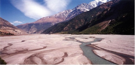
24 Oct 22 Walk from Dallebokhori (3460 m) to Kagbeni (2915 m).
A very short day. We descend on easy tracks to the Kali Gandaki river (2850 m) and cross it via the suspension bridge at Kagbeni. This is the world's deepest valley, dominated by two mountain ranges over 8000 m: Annapurna and Dhaulagiri. Lunch and overnight camp in the backyard of a trekkers' lodge. Plenty of spare time to explore the village and the busy monastery.
1:50 h walk, +65/-610 m ascent/descent.
25 Oct 23 Walk from Kagbeni (2915 m) to Jomsom/Puthang (2745 m).
Another short day. Some of the way we walk along the road, some along a track near the river. We pass through Jomsom and reach Puthang where we have lunch and camp overnight in the backyard of a trekkers' lodge. You will have plenty of spare time to explore the village. The evening brings a Tombola and a festive dinner.
3:00 h walk, +40/-210 m ascent/descent.
26 Oct 24 Fly to Pokhara (785 m) then on to Kathmandu (1400 m).
All heights were measured using various altimeters or GPS and are believed to be accurate to +/- 30 m.
All publicly available maps in Kathmandu in October 2012 were highly inaccurate and did not show correct heights.

Lamjung Base Camp from Pokhara
Day 01:
KTM – PKR
Day 02:
Drive to Lama Bazar – Camp at Lam Khet
Day 03:
Lunch at Tanding – Camp at Biabi Kharka
Day 04:
Lunch at Gorase Ghari – Camp at Ramdung Danda
Day 05:
Lunch at Dobato – Camp at Lamjung B.C.
Day 06:
Cross the Pass 4, 900 m – Camp at Kopche pani.
Day 07:
Lunch at Ghan Pokhara – Camp at Baglung Pani
Day 08:
Besi Sahar for Lunch - KTM
Dolpo (Nepalgunj / Nepalgunj)
Day 1:
Arrive Kathmandu. Transfer to our hotel. We'll have an orientation meeting this evening at the hotel, then go out for dinner in town.
Day 2:
Free day in Kathmandu. There will be a half-day tour of some of the most outstanding historic sites in town.
Day 3:
Mid-day flight to Nepalgunj in the southwest of Nepal. We'll take a bicycle Rickshaw tour of this interesting town, visit the bazaar and the Baseshowri Temple - one of the most important Hindu temples in Nepal.
Day 4:
Early morning flight over steep, mountain ridges with beautiful views of snowcapped mountains to the town of Juphal, at 8100'. Take a short trek up the Thuli Bheri River, then along the Suli Khola River and enter the evergreen forest with periodic bamboo groves. This is a lovely walk along the emerald green river. After 6 hours we'll reach our camp by the river at Chhepka, at 9300'.
Day 5:
Walk 6 hours along the river among the forests and the cliffs. This is an active trail with many locals and their yaks going to and from local markets. Once we settle into our campsite near the town of Chunuwar (10,200') we'll visit the Amchi Hospital where traditional Tibetan medicine is practiced. All doctors here are also Lamas.
Day 6:
It takes just 3 hours to reach today's camp at Ringmo (12,250'), on the shores of stunning Phoksundo Lake, but much of it is steep. Along the way we'll pass Suligad Falls, at 550' Nepal's highest waterfall. Ringmo is a charming village where the people practice the ancient Bonpo religion, which pre-dates Buddhism. (Remember to pass the Mani Walls counter-clockwise here, the direction preferred by Buddhists.) We'll take time this afternoon to visit a Bonpo monestary.
Day 7:
Free day at Ringmo/Phoksundo Lake.
Day 8:
This morning we'll walk high above the lake on the 'Demons Trail' with majestic views in all directions. After lunch on the lake's northern shore we'll enter a broad valley that leads to our camp at Chunemba (12,800') among the juniper trees.
Day 9:
Walk 7 hours up into the high dry countryside, where you will be surrounded by immense mountains. Snowfields Camp (14,400') was named by Peter Mathiesson in his book, "The Snow Leopard".
Day 10:
It's a strenuous 3 hour climb to Kang La Pass (17,500'), marked by countless prayer flags, followed by 3 more hours down to Shey Gompa (14,150'). This 11th C gompa is located beneath Crystal Peak and is the spiritual center of Dolpo. It is said to have been built by a Buddhist Lama who arrived on the back of a flying snow lion. It's a magical place. Every year hundreds of pilgrims come to make the 'kora' (circumambulation) of Crystal Peak.
Day 11:
A free day at this important spiritual place, to explore Shey Gompa, as well as Tsakeng Gompa, located high above on a red rocky slope. Many Blue Sheep live in this area and we're likely to see flocks of them. This is also an excellent place to see snow leopards.
Day 12:
We'll climb over 2000' through a narrow valley to cross Shey La (16,400'). Great views out over Tibet to the north and into Mustang to the east. Our descent takes us among scattered fields to the settlement of Namgung (14,530'). 6 hours.
Day 13:
The path goes high above Namgung Khola (River) and then descends steeply to the village of Saldang (13.315'. 3 hours). This is the largest town in Inner- Dolpo. The people here grow barley, buckwheat and potatoes, they raise yaks and sheep, and they're involved in the salt trade with Tibet.
Day 14:
It's a fairly easy 5 hour walk to Sibu at 13,780', passing small villages surrounded by terraced fields of barley.
Day 15:
The trail starts along the river, then turns away and ascends through a valley inhabited with blue sheep. After 7 hours we'll camp in a meadow called Lagmo Che at 15,000'.
Day 16:
Climb steeply to Jeng La Pass at 16,760', with great views of 26,790' Dhauligiri, and many other snowcapped mountains. We'll reach the village of Tokyu (13,800') in 7 hours. This is one of the highest permanent settlements in the world.
Day 17:
After a short 2 hour walk we arrive in Dho-Tarap (13,380'). This is a traditional Dolpo agricultural village, but it has two interesting gompas. Ribo Bhumpa Gompa contains a giant statue of Guru Rinpoche, also known as Padmasambava, a powerful lama and saint from the 7th C. credited with introducing Buddhism to Tibet. On the hillside above the town is Shipchaur Gompa which is a rare Bonpo site.
Day 18:
Descend steadily down the Tarap Khola as the vegetation becomes thicker and greener. After 7 hours we arrive at Chhyugar, at 11,300'
Day 19:
Today we have many miles to cover, descending 8 hours to Khanigaon at 8200'. This trail is sometimes handsomely carved directly out of the bedrock. Ultimately we get back into the forest, and camp in the outskirts of town.
Day 20:
The trail drops steeply for sometime, following the river and the steep canyon walls covered with thick forests of juniper, spruce and fir. At times the river is far below, at others we walk along the shore. Along the way there is a Bonpo school, one of the few places anywhere that still teaches the Bonpo religion, along with Tibetan culture and language. Then we level out through villages and farmland and after 7 hours we arrive at Juphal at 8100', up on a high bench above the Thuli Bheri River.
Day 21:
Free day.
Day 22:
Early this morning we'll fly to Nepalgunj, and then on to Kathmandu, where we'll check into our hotel. Tonight we'll celebrate out on the town.
Day 23:
Free day in Kathmandu. Flights home.
NB:
Some people may wish to stay an extra day or two in Kathmandu to enjoy and explore this fascinating city. We encourage you to do so.
Lower Dokpo with Phoksundo Lake
Day 01: Arrival day in Kathmandu (1,300m/4,264 ft)
Namaste and welcome to Himalayan Planet of Nepal. When you land at the Tribhuvan intl. airport Himalayan Planet Adventures representative welcomes you with your name and helps to transfer you to your hotel in Kathmandu. After some time to refresh, you will be brought to the head office and listen to a briefing about the program. In the evening we'll pick you up for the Welcome Dinner at a typical Nepalese restaurant in the heart of Kathmandu. During dinner you will be able to watch a cultural program before returning to your hotel.
(Welcome dinner and deluxe hotel accommodation included)
Day 02: A guided sightseeing in Kathmandu Valley
After breakfast you will go on a guided day trip to visit the world heritage sites and surrounding areas in the Kathmandu valley. We take you to visit the pilgrimage site of Hindus, the temple of Pashupatinath, which is one of the most important and most visited shrines of Shiva on the subcontinent. Here you can see the Saddhus (holy men/Baba) and cremations on the holy riverbank of the Bagmati. Hundreds of monkeys run around exploring with you!! You will also visit Bouddhanath stupa - another pilgrimage centre, popular and important for Buddhists. You can sping the prayer wheels and marvel at the fluttering, colourful prayer flags.
After visiting Bouddhanath stupa we'll drive to the City of Devotees (Bhaktapur). This traditional and traffic free town is the third biggest town in the Valley. We'll explore the medieval like squares, courtyards and temples of this vibrant town. After a stop for lunch at a restaurant in Bhaktapur it's time to drive back to Kathmandu for an overnight stay and to prepare for the next day. Groups who wish can choose sightseeing options inside the Kathmandu valley rather than those given above.
(Breakfast and Deluxe hotel accommodation included).
Day 03: Fly from Kathmandu to Nepalgunj and overnight at Hotel.
Today you'll be transferred to the domestic airport for a one hour, scenic flight to Nepalgunj. Here we will have time in the late afternoon or evening to explore the town which is situated on the southern Nepal border with India and has a hot tropical climate. Overnight in the hotel.
(Breakfast and Standard hotel accommodation included).
Day 04: Fly to Juphal (Dolpa) and trek to Dunai (2,850m/9,348ft)
You will be transferred to the airport for an early morning, 40 minute flight to Juphal (2,320m/7,610ft). On arrival our trekking staff will greet you, after walking from Nepalgunj with the camping gear and food supplies for the next 5/6 days. Our first day's adventure begins with a one hour downhill walk through the village below the airstrip, and a further 3 hour walk through the terraced fields to the Bheri River and the narrow gorge to camp at Dunai. This village is the administrative headquarters of the Dolpo region and even has a new hospital.
(Breakfast, lunch, dinner and tented accommodation are included)
Day 05: Trek to Tarakot (2,850m/9,348ft)
The journey leads through many small streams and then follows the Bheri and Barbung river in a tremendous gorge with pine trees and an ingenious path built about seven meters above the river. After a good walk we will arrive at Tarakot, greeted by colourful, terraced fields. Tarakot, the capital before the Gorkha dynasty, is an old fortress town built by the local people as a Dzong or fort. The famed Sandul gompa lies farther east from Tarakot, at the junction of Barbung khola and Tarup chu (river). The village stands on a hillock to the south of the Bheri River and at one time supervised collection of tolls for the trading caravans. After a 5-6 hour walk we reach the overnight camp.
(Breakfast, lunch, dinner and tented accommodation are included)
Day 06: Trek to Kami Gaun (2,543m/8,341ft)
As our journey continues we follow the Tarap chu river upstream. Crossing it twice, during a 3-4 hour walk, the path goes through the farm terraces and rural villages of Sahartera before winding gradually towards the small settlement of Kola. After a further 2 hour trek uphill we reach our overnight camp at Kamigaun.
(Breakfast, lunch, dinner and tented accommodation are included)
Day 07: Trek to Tarap Khola (3,450m/11,316ft)
We follow the Tarap River upstream through the valley. On the way we are likely to encounter people from Dolpo herding their flocks of sheep and goats to lower pastures for the winter. The walk is quite exciting as the valley becomes a narrow gorge that in some places you can jump from one side to another. Sometimes the path vanishes for a while, forcing us to make our own path across stone slabs resting on logs in between the walls which act as a bridge. The gorge also provides unexpected adventure and thrills and in some places the bridges are either damaged or have been washed away by the monsoon flood, leaving the only option to cross the cold torrent by foot. Our overnight camp is by the river just before Kamattarka village.
(Breakfast, lunch, dinner and tented accommodation are included)
Day 08: Trek to Yak Kharka
As we continue to follow the trail upstream along the lush valley with its natural beauty, a 5-6 hour walk takes us to the overnight camp at Yak Kharka (Yak grazing pasture) where you can enjoy the dancing and singing with our Himalayan planet of the World crew.
(Breakfast, lunch, dinner and tented accommodation are included)
Day 09: Trek to Dho Tarap (4,090m/13,415ft)
After a Himalayan breakfast we start to walk gradually uphill to Kamattarka which is at the confluence of the Tarap Chu and Lang Khola, a stream flowing from the east. After few hours of a good morning walk we leave the narrow gorge and from here the path leads to just above the tree lines where juniper bushes and wild roses grow - typical vegetation of the dry, inner Himlayan valleys. An approximate 3 hour walk brings us to a village, surrounded by an irregular stone wall, called Dho Tarap. At Dho, thirty-four houses, built randomly, are divided into three groups. In this valley both Bon Po and Chaiba sects reside together. Tarap is also inhabited by few Tibetans and mostly Magars who have lived there for many generations. Another 6 hour walk takes us to our overnight camp.
(Breakfast, lunch, dinner and tented accommodation are included)
Day 10: Acclimatization at Dho Tarap
Today is a rest from the hassle of daily packing and a chance to explore the beautiful village and chance to make friends with the locals who hardly see Westerners. The Dolpo people wear home spun clothing that is sometimes dyed maroon and they favor Tibetan style Somba or Dhocha (boots with upturned toes) for foot wear. Both men and women often wear religious amulets and strings of coral, amber and turquoise. The people of the region are both Bon po and Nyingmapa of the Buddhist sect. The Buddhist Gompa is near the camp while the Bon Gompa (pre-Buddhist) is about half an hour's walk.
(Breakfast, lunch, dinner and tented accommodation are included)
Day 11: Trek to Tokyu Gaon
As our journey continues towards the upper Tarap valley, you will see in this plain valley, patches of lush, verdant grass on both sides of the river, which is completely different from other parts of inner Dolpo. This pleasant track winds by the Tarap chu upstream all the way. Tarap is certainly a dream valley with vast plains in high mountains extending twenty kilometers along the river Tarap Chu. There are ten villages with cultivated fields of barley, buck wheat, wheat and potato. After 3-4 hours walking in this perfect tranquility we arrive at the village of Tokyu, where there is a Chiba sect monastery. After a short break our walk continues farther up the valley climbing the rough track for almost another three hours to reach our overnight camp beneath the Numa-la on a pasture.
(Breakfast, lunch, dinner and tented accommodation are included)
Day 12: Trek below Numala pass.
The trail leads us towards the two high passes of Numa La and Baga La. As we continue ascending we follow the northern valley, walking in the Himalayan desert and able to view snow capped mountains in this wild Himalayan zone. During the walk you will begin to feel the altitude and may have difficulty walking. The day will be short but tiring due to the altitude. We camp overnight at this high altitude.
(Breakfast, lunch, dinner and tented accommodation are included)
Day 13: Trek Numa La pass (5,190m/17,023ft) to Phedi
As our journey continues we cross the Numa La pass, which will be difficult but a great experience. The track follows a steep climb to the top ridge of Numa La where you will have great views of the surrounding landscape, scenery of the valleys and mountains - including the north face of the Dhaulagiri massif along with other distance snow capped peaks. The top is marked by fluttering, Buddhist prayer flags and if you want you can stay at the top for some mountain peace. Today is one of the longer and more difficult days, taking 7 hours to reach the top at Numa La but after this we descend to Phedi for our camp.
(Breakfast, lunch, dinner and tented accommodation are included)
Day 14: Trek Baga La Pass (5,070m/16,630ft) to Phedi
(4,470m/14,662ft) Another hard day trek starts with a steep climb to reach the ridge top of Baga La, which offers fantastic views of the surrounding landscape and of the distant snow capped peaks of the Kanjirowa Himal range. After a glorious moment on the pass, almost three hours of downhill walk takes us to the Phedi for the overnight at camp.
(Breakfast, lunch, dinner and tented accommodation are included)
Day 15: Trek to Ringmo (3,600m/11,808ft)
The trek starts after breakfast and packing. Firstly, we walk through the pine forest and then as the vegetation changes to pasture and alpine shrubs we make our way to Ringmo and the beautiful Lake Phoksundo where we camp overnight.
(Breakfast, lunch, dinner and tented accommodation are included)
Day 16: Hike to Phoksundo Lake.
Today, one of the most beautiful days is free, although after breakfast we head off to explore Phoksundo Lake. It is possible to walk around the surround areas and visit a Tibetan Buddhist monastery. The area provides a great view of Crystal lake, the surrounding hills and snow capped mountains. Overnight camp.
(Breakfast, lunch, dinner and tented accommodation are included)
Day 17: Trek to chepka (2,250m/7,380ft)
On the trail from Ringmo to Chepka there is a massive overhanging rock and some small villages. Many important medicinal minerals, which are believed to cure almost anything, can be found in this area. The last part of the climb takes us to the pasture at Chepka for the overnight camp.
(Breakfast, lunch, dinner and tented accommodation are included)
Day 18: Trek back to Jhupal Airport.
The trail gently slopes upwards towards Jhupal village. We pass the birch tree forest and the ridge top where we have the most spectacular mountain views and views of Jhupal village below. Extreme caution is required while trekking along this trail. After reaching Jhupal, we spend our afternoon exploring the busy market town or simply doing whatever we feel like. We enjoy our last day celebrations with the crew, during which we have a farewell dinner and tips are distributed, before the final overnight camp.
(Breakfast, lunch, dinner and tented accommodation are included)
Day 19: Reserve day for flight schedule
Juphal is in a remote area so only morning flights are operated and these are regularly interrupted by wind and cloud. Therefore, this day is a spare day so that if the flights do not operate in Juphal we can fly the following day to Nepalgunj with an overnight in the hotel.
(Breakfast, lunch, dinner and hotel/tented accommodation are included)
Day 20: Fly to Nepalgunj and connecting flight to Kathmandu
Today, if the flight did not operate yesterday then we take a morning flight back to Nepalgunj and an afternoon flight to Kathmandu. You Trekking guide will only be with you until Nepalgunj but before saying goodbye he will ensure you are on the flight to Kathmandu. We will meet you at Kathmandu airport and transfer you to the Hotel where you will be able to relax for the remainder of the day.
(Breakfast and deluxe hotel accommodation included).
Day 21: Leisure at Kathmandu
Today is day for leisure activities of your own choice, you may want to do some shopping in Thamel or you can extend your trip with us at an additional cost. In the evening the company will meet you for the farewell dinner. Overnight at your hotel.
(Breakfast, farewell dinner and deluxe hotel accommodation included).
Day 22: Departure from Kathmandu
Today is free for any extra trips or activities you may have booked with us or some last minute shopping for souvenirs or gifts for your family, friends or relatives until your departure. If departing, you'll be transferred to the International Airport for your departure flight to your onward destination.
(Breakfast included).
Annapurna Curcuit Trek
Day 01 BESISAHAR (760m)
Drive from Kathmandu to Besisahar, about 6 hrs. on a paved road. Overnight at Besisahar.
Day 02 DHARAPANI (2,050m)
After a relaxed breakfast, leave Besisahar for Dharapani, the starting point of the trek. From Besisahar the newly built road to Manang is not paved, so we take a four wheel drive vehicle (Jeep) from Besisahar to Dharapani – 4 hr drive. Spend the night here before beginning the trekking.
Day 03 CHAME (2,530m)
Start walking from Dharapani, along the Marsyangdi river via Timang, Lata Manang and reach Chame (2530m) for overnight. Chame is the District Headquarter for Manang district. Total walk about 6 – 6 and half hours.
Day 04 PISANG (3,354m)
Trek through Bratang village and begin the spectacular ascent to Pisang into the rain shadow area. Walk through a magnificent forest with the Marsyangdi river roaring below, gaining momentum to break its way through the line of main Himalayan range between Annapurna II and Manaslu. Total walk to Pisang – 6 hrs.
Day 05 MANANG (3,351m)
A beautiful day on relatively easy terrain through the forest. The southern tier of this valley is walled by Annapurna II and IV, Annapurna III, Gangapurna and Glacier Dome the west. The path crosses a plain and passes Hongde airstrip (3415m). There are splendid views of peaks from both Braga and Manang. Manang is a large village situated on a rise immediately across from a huge glacier descending from Glacier Dome and Gangapurna. 7 hours via Gyaru village, to the north.
Day 06 MANANG
A day for rest and acclimatization. Take a day's walk around the village or visit the monastery.
Day 07 YAK KHARKA (3,963m)
A short day for acclimatization about a 4 hour walk from Manang. A side trip up the stream following down from the West Chulu Peaks can be done in the afternoon.
Day 08 THORONG PHEDI (4,405m)
The trail turns northwest up the tributary valley of the Jharsang Khola. It is sometimes possible to see herds of blue mountain sheep along the cliffs. This (Phedi) is the base for crossing the high Thorong Pass. 5 hours.
Day 09 MUKTINATH (3,810m)
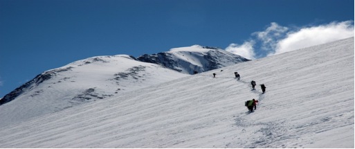
Ascend steeply for about 2 hours to a rock ledge at 4950m. Then along an undulating trail to the flat top of Thorong La (pass), 5396m. Views of the Annapurna range to the south and Mukut Himal bordering Dolpo to the west. The peak immediately to the north of the pass is Thorong Peak. A steep descent downhill trail for about 3 hours to Muktinath – total about 10 hours from Phedi, a long and hard day of trekking.
Muktinath is one of the most important pilgrimage sites, both for Hindus and Buddhists. There are 108 stone carved spouts surrounding the Vishnu temple in a grove of sacred poplars.
Day 10 JOMSOM (2,713m)
The walk is mostly downhill to Jomsom and is the last day of trekking, about 5 hours walk via Jharkot, Khingar, Eklebhatti.
Day 11
Take a short but interesting flight to Pokhara airport then a flight to Kathmandu.
NOTE/ OPTIONS
The trek can be extended by continuing the walk down the Kali Gandaki valley via
MARPHA (Day 10)
KALOPANI (Day 11)
TATOPANI ( Day 12)
GHOREPANI (Day 13)
HILE (Day 14)
POKHARA Day 15)
Or instead of walking along the newly built road, take a jeep from Muktinath to Tatopani (7 hours). Then walk to Ghorepani – Hile – end trek at New Bridge then drive to Pokhara (13 days), or drive all way to Beni from Muktinath (Day 10) (10 – 11 hrs). Then drive onto Pokhara, ending the trip.
Panchase Trekking
Day 01:
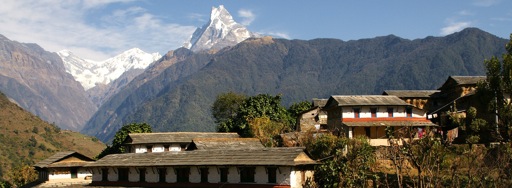
Drive from Pokhara to Thado Khola – 30 minutes and Thado Khola to Bhumdi (1600m) – 3 to 4 hours After breakfast, we start our journey with an early morning 30 minute drive to Thado Khola via David Falls. Your trekking crew will arrange all the trekking gear in Thado Khola. The trail, which takes 2 and half hours, ascends towards Bhumdi village. We stay overnight in a traditional Bhumdi Gurung village with beautiful views of Ganesh Himal, Himalchuli, Manaslu, Annapurna range and Fishtail Mountain touching the skyline.
Day 02:
Trek Bhumdi to Panchase Bhanjang (2000m) – 5 to 6 hours The trail ascends westward through bush forests for an hour and if the weather allows we can see the entire mountain vista to the North. It will be a pleasant day for those who are interested in birds. After 3 hours walking, we have lunch and then walk on a gentle trail for 2 hours through the forest again. Finally the trail ascends to Bhanjyang for one and a half hours with more spectacular mountain vistas, the Pokhara Valley and Phewa lake. Stay overnight at tented camp.
Day 03:
Trek Panchase to Bhadaure (1700m) – 4 to 5 hours After breakfast, the trail goes through the beautiful forest to the highest view point Panchase Ride at 2500m, offering views of Pokhara and the Kusma Valley. All the Annapurna range and the giant peak of Dhaulagiri are visible at this point. The trail then descends through pastures and scattered forest for overnight to Bhadaure.
Day 04:
Trek Bhadaure to Dhampus(1580m) via Kade We finish our journey at Naudanda uphill from Kade, through one of the best view points, Australian Camp and then descend to Dhampus; a unique cultural Gurung village with astonishing mountain views of Annapurna, and Fishtail as well as green hills. The sun rise and sun set is magnificent attractions for visitors.
Day 05:
Trek Dhampus to Phedi (1080m)- 1:45 hours, Drive to Pokhara (950m) – 40 minutes Today is the last day trekking. We walk downhill through the village to Phedi through the forests and manicured fields that resemble a city park due to overgrazing. The trail falls down steeply to the ridge at Phedi (1080m). We then catch our vehicles and drive to Pokhara for lunch. After lunch you are free to discover more in Pokhara.
Day 06:
Drive back to Kathmandu early in the morning by tourist bus- 6 to 7 hours We will be ready to leave the hotel at 6:00 am after having breakfast. We will drive back to Kathmandu through the road passing terraces, streams, rivers, local settlements , high hills and along the river side. It takes about 7 hours to reach your hotel in Kathmandu.
Annapurna Circuit Trek
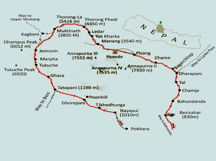
Now that the road is extended and reaches Dharapani, the popular Annapurna Massif Circuit trek is shortened. The road is black topped up to Besisahar, but from Besisahar it is not paved. It is a 5 hr drive to Besisahar and the following day the drive to Dharapani is 4-5 hrs. The trail passes through the Manang valley gorge to the Buddhist settlements of Tibetan origin.
This more arid, rocky country contains villages of stone houses clinging to steep hill sides. At the end of the valley we pass through yak pastures and over the Thorong La (pass) at 17,764ft. to the religious complex at Muktinath. Holy to both Hindus and Buddhists, Muktinath features an eternally burning flame and 108 boars head water spouts.
ITINERARY
Day 1: Besisahar to Bahundanda
From Besisahar the trail descends and follows the gentle slope of the Marsyangdi Khola and reaches Khudi. Khudi which is at an altitude of 830 meters. The trail then reaches Bhulbhule (840 meters) from where Himalchuli and Ngadi Chuli (also known as Manaslu 2) mountains can be seen. The trail then passes through Ngadi and climbs to Lampata (1135 meters). The final stretch reaches Bahundanda, which is at an altitude of 1310 meters and where there are several hotels, shops and a public telephone.
Day 2: Bahundanda to Chamje
From Bahundanda, following an exposed trail, the route descends to Lili Bhir and after to a beautiful, high waterfall at Ghernu. The trail continues and crosses the Marsyangdi River by a suspension Bridge in Syange which is at an altitude of 1080 meters. Following the Marsyangdi River, the path reaches the small, stone village of Jagat. From here the trail descends and then ascends through forest and reaches Chamje, which is at an altitude of 1400 meters.
On the Annapurna circuit
Day 3: Chamje to Bagarchhap
From Chamje the trail is rocky and follows the Marsyandi Khola, steadily ascending to Tal (1700 meters) which is the first village in the Manang district. After climbing a stone stairway and descending a little the trail crosses the Marsyangdi River again. A further ascent takes you to Dharapani (1920 meters), which is marked by a stone-entrance chorten. From Dharapani the trail climbs to Bagarchhap, which is characterized by flat-roofed stone houses and which is at an altitude of 2160 meters.
Day 4: Bagarchhap to Chame
From Bagarchhap the trail ascends to Temang and continues to rise through pine and fir forests to Kotho (2640 meters). Climbing to Chame (2710 meters), the headquarters of the Manang district, Annapurna II can be seen. There are many hotels, a health post and a bank in Chame.
Day 5: Chame to Pisang
From Chame, the trail runs through deep forests along a steep, narrow valley and eventually crosses the Marsyangdi Khola at an altitude of 3080 meters. Along the trail the view of the Paungda Danda rock face is spectacular. The final stretch of the day, continues to rise to Pisang, which is between 3240 meters and 3340 meters and where there are many lodges.
Day 6: Pisang to Manang
From Pisang there are two trails, north and south of the Marsyangdi Khola and which meet again at Mungji. The southern trail passes through Hongde (3420 meters) and has an airstrip at an altitude of 3325 meters. Taking the southern route involves less climbing, whereas the northern route, passing through Ghyaru, has better scenery.
From Mungji, which is at an altitude of 3480 meters, the trail continues to Bryaga (3500 meters) and further to Manang (3570 meters), where there are a number of lodges, the Himalayan Rescue Association and shops to buy supplies such as batteries, sunscreen and even chocolate. Don't miss the spectacular view of Gangapurna glacier from Manang.
Day 7: Acclimatization in Manang
A day to explore the village of Manang and to acclimatize before attempting the Thorung La pass.
Day 8: Manang to Letdar
From Manang, the trail ascends through Tengi, leaving the Marshyangdi valley. Then it head towards the Jarsang Kholar (river) valley and reaches Letdar, which is at an altitude of 4250 meters and where the vegetation becomes sparser. Spending a night in Letdar is very important for acclimatization before attempting Thorung Phedi.
Day 9: Letdar to Thorung Phedi
The trail crosses the Jarsang Khola (4310 meters) and climbs to Thorung Phedi, which is at an altitude of 4420 meters.
Day 10 Thorung Phedi to Muktinath
This regularly used and therefore easy to follow part of the trail ascends steeply to Thorung La, which is at an altitude of 5416 meters and will take about four to six hours. At this point the snow and altitude can often cause problems. The pass is marked by chortens and prayer flags and a view of the Annapurna, along the great Barrier to the barren Kali Gandaki Valley can be seen from Thorung La. From Thorung La, the trail descends and reaches Muktinath, which is at an altitude of 3710 meters.
The remaining six or seven days is the reverse of the Jomsom Trek. You can also fly out of Jomsom but we suggest you continue the walk down to Tatopani and further down to Ghore pani and then to Pokhara to enjoy fully the adventure along the circuit.
NOTE/ OPTIONS
The trek can be extended by continuing the walk down the Kali Gandaki valley via
MARPHA (Day 10)
KALOPANI (Day 11)
TATOPANI ( Day 12)
GHOREPANI (Day 13)
HILE (Day 14)
POKHARA Day 15)
Or instead of walking along the newly built road, take a jeep from Muktinath to Tatopani (7 hours). Then walk to Ghorepani – Hile – end trek at New Bridge then drive to Pokhara (13 days), or drive all way to Beni from Muktinath (Day 10) (10 – 11 hrs). Then drive onto Pokhara, ending the trip.
Annapurna Sanctuary
Day 01 TIKHEDHUNGA (4,900’/1494M.)
The trek begins with a short drive from Pokhara airport to the New Bridge before Birethanti. Trail follows east bank of the Bhurungdi river with some detours to avoid cliffs. Tikhedhunga is reached in about 3-½ hrs. for camping / Lodge.
Day 02 GHOREPANI (8,900’/2713M.)
The day entails a climb of over 4,000’/1220m., but the trail is fairly good. First, very steeply up Ulleri village (6600’/2012m.) 2 hrs. then, more pleasantly, through rhododendron forest. There is a hut and water and a small campsite about 1 hour above Ulleri, and further on the stream is followed, providing water for a meal halt. There is an excellent campsite at Thante at 8000’/2439m. 3 hrs from Ulleri (five from Tikhe) which can be used by a tired party lacks only view of the snows. The top of the Ghorapani pass is about 1 ½ hours further on. The small settlement of a few house 200 feet below the pass does provide good water and a fair campsite, but it is much better to continue along the track and reach a campsite just over the forest of the ridge. However this is sometimes crowded and a better site, more remote, lies to the west of Poon Hill. Worth the effort. Both offer outstanding views of the whole Dhaulagiri range. Total 6-7 hours.
Day 03 KYMNU DEURALI
The route continues through the forest. Lunch at Banthanti. Views are obstructed as this place is on a narrow streambed. Good views of mountains will soon be visible from the trail after leaving Banthanti. Camp at around 9000’/2740m.
Day 04 CHOMRONG
Dropping down the hillside Kymnu offers a good spot for an early lunch, a swim and a wash up. After lunch the route starts the long ascent high above the West Bank of the Modi Khola. The village of Chomrong (6500’/1918m) lies tucked down at the very base of Huinchuli (20732’/6336m). Time 6 hours.
Day 05 HINKO CAVE (10400’/3170M.)
Proceed to Kuldi Ghar about 3 hours. The name Kuldi is properly speaking applied to a single house (Kuldi Ghar) perched on the steeping West Side of the valley. There is clearing in the forest as little further on. From Kuldi the route goes very steeply down a band of rock and then levels out, running through thickets of bamboo in the bottom of the gorge, keeping always on the West Side of the river. The pasture of Tomo is passed, and then the very neck of the gorge at Panchenin Barha, where there is a small trailside shrine. (When the first outside “Explorer” came here in 1956 there was a taboo against women, men of menial cast, pork, chicken and eggs being taken past the spot). The gorge widens beyond Panchenin Barha, and the track climbs to Hinko Cave. From the first big cave descend a short way and cross a broad gully full of avalanche debris. Then climb to better campsites and some smaller caves. Kuldi to Tomo (good camp or lunch spot at 8400’/2560m) is about 2 ½ hours, and from there to Hinko another 2-3/4-5 ½ in all.
Day 06 SOUTH ANNAPURNA GLACIER BASIN (12000’/3858M.)
The track remains on the West Bank of the Modi, now flowing through a more open valley, and eventually emerges into the Sanctuary. Straight-ahead is the high lateral moraine of the south Annapurna glacier and the Modi flows in a deep cleft on the right. This is the site of the Machapuchare Base Camp (1957) and one can either camp here or continue northwest, staying above the glacial moraine. NOTE: During the early spring keep a look out for snow avalanches pouring down the gully or funnel which has to be traversed soon after leaving the upper Hinku campsite. After a period of heavy snowfall referred to earlier, below the big cave, may also be dangerous, although quite easy to cross.
Day 07 ANNAPURNA SOUTH FACE CAMP VISIT:
On up the broad grassy path referred to above for about 1 and a half hours, and then climb on to the lateral moraines and down the other side onto the glacier. Walking up the bed of the glacier is safe and quite easy and the 1970 British Expedition Base Camp (and grave of Ian Clough) is reached after another 1 ½ hours. Base Camp is at 13900’/4237m. The trip is best done form the lower camp, carrying only lunch, and the best views are probably obtained from the crest of the moraine, which may be followed in its upper reaches until cut by the glacier flowing down from Huinchuli to the north. Return to camp around teatime.
Day 08 DOBHAN (7500’/2286M.)
Descent follows same route to pleasant camp spot at Dobhan. Time 5 hours.
Day 09 MODI KHOLA:
ON past Kholdi Bikas where there is an Experimental Sheep Farm. The trail continues through rhododendron and bamboo. After Chomrong the trail continues steeply up stoned steps to Kabrey Chautara and soon after the trail to Landrung leaves the Ghandrung path dropping away towards the river. After crossing the river the camp is sited nearby on the east bank of the river. Time 6 ½ hours.
Day 10 FOREST CAMP (6076’/1052M.)
The trail climbs quite rapidly to the Gurung village of Landrung (5281’/1610m) after which there is generally pleasant trekking through farmland with odd scattered houses and the occasional school. After lunch there is a longish climb through rhododendron before cresting the ridge and dropping down towards Dhampus. There is a beautiful campsite in the forest an hour above Dhampus. Time 7 ½ hours.
Day 11 POKHARA: LAKE SIDE CAMP OR HOTEL:
Follow the ridgeline down to Dhampus then there is a steep descent down to the Yamdi Khola valley to the settlement at Suikhet. A bus or taxi could then be taken down through Pokhara and the afternoon spent on or about the lake or stay in a hotel or a guesthouse. This might be advisable during the hot months for people who want extra time in Pokhara.
Day 12 FLY / DRIVE TO KATHMANDU
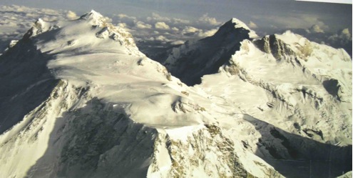
Around Dhaulagiri Trek
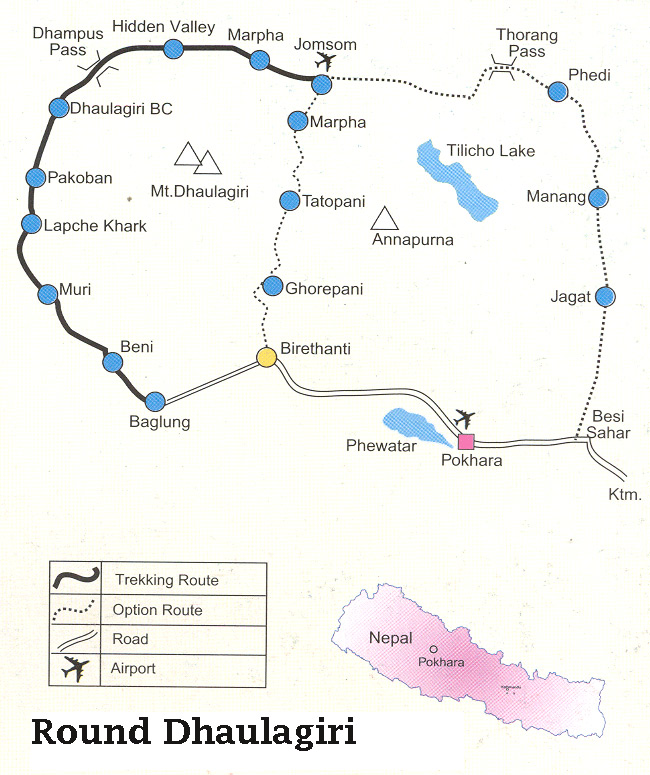
This trek is very remote wilderness area, up the Myagdi Khola valley, behind the gigantic Dhaulagiri. The French Pass and Dhampus pass can be crossed during favorable weather conditions. The notoriously unpredictable weather near Dhaulagiri, Camping in Hidden Valley can be very risky, where a sudden weather change might block the route to Kali Gandaki. The crossing of these passes can normally be made in early autumn or in late spring.
Options:
1. End trek at Jomsom and fly out to Pokhara (14 days trekking)
2. Continue down the Kali Gandaki Valley, via Ghorapani, ending the trek at Birethanti, New Bridge, drive to Pokhara (19 days trekking)
TREK GRADING: D
Detailed Itinerary
Day 01:
13-Oct Fly to Pokhara. drive to Beni - 810m (lodge)
Day 02:
14-Oct Babichaur - 950m (lodge)
Day 03:
15-Oct Dharapani - 1500m (lodge)
Day 04:
16-Oct Muri - 1800m (tea house)
Day 05:
17-Oct Bagar - 2000m (tea house)
Day 06:
18-Oct Dobhan - 2400m - start camping
Day 07:
19-Oct Sallaghari - 3000m
Day 08:
20-Oct Italian B.C. - 3500m
Day 09:
21-Oct Japanese B.C. - 4100
Day 10:
22-Oct Extra day for rest / weather
Day 11:
23-Oct Dhaulagiri B.C. - 4600m
Day 12:
24-Oct Hidden Valley - Cross French Pass - 5334m
Day 13:
25-Oct Yak Kharka - 3962m
Day 14:
26-Oct Jomson - Lodge
Day 15:
27-Oct Fly to Pokhara - then to KTM
Around Manaslu
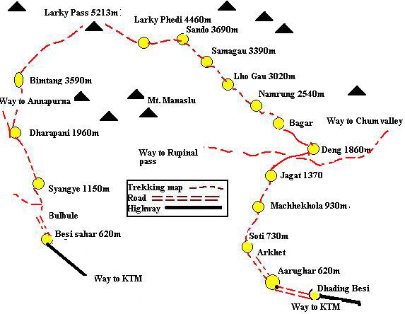
Day 01 Arughat Bazaar (1200'):
The trek starts after a six hour drive from Kathmandu to Arughat.
Day 02 Soti Khola (1500'):
Cross the river and walk northwards along the western bank through agricultural land, scattered villages and views of Ganesh Himal to the northeast. Camp by the river where washing and bathing is also possible. Time – approximately six hours.
Day 03 Beyond Labubesi (1900'):
Cross the Soti Khola and continue walking northwards up the valley. Very few mountain views are available at this point. Lunch can be taken after 2 ½ hours next to the riverbank and then it is another 2 ½ hours or so of ups and downs which lead to a small but beautiful village, Labubesi. Camp beyond the village – time five to six hours.
Day 04 Before Dobhan Khola (2700'):
Continue walking north up the line of the valley. Be careful to keep on the correct trail since there are two trails leading to the Macha Khola, one being a lot longer than the other. Lunch at Macha Khola. Cross the bridge over the river and continue on for about an hour before the trail ascends slightly towards the west for another hour to finally reach some hot springs (Tatopani). The Buri Gandaki is crossed and it is a 2-½ hour walk along the eastern bank before the campsite is reached. Total time – 7 ½ hours.
Day 05 Jagat (4500'):
Continue upstream along the eastern bank of the river for 2 ½ hours. The trail then passes through a huge landslide area for approximately 10 minutes (which will obviously change every year) and care should be taken. A further 20 minutes will bring you to Yaro Khola where there is a beautiful, perfect lunch next to the river. Cross this tributary and continue up the Buri Gandaki River until the village of Jagat. The village is mainly inhabited by Gurungs with a Police Check post and even a post office and a bank. Time – approximately six hours.
Day 06 Ngyak:
Leave Jagat and walk along the riverbank for an hour followed by a 45 minute uphill climb. Then walk towards Setibas for about 30 minutes downhill and onto Ghattekhola where lunch may be taken. Cross Ghattekhola across a bamboo bridge and continue on a wide trail. Relatively easy walking takes you into Ngyak where the evening camp may be just beyond the village. Time – five hours.
Note:
In case of emergency, radio contact is available at Philim where they have contact with the District Head Quarters (Ghorka).
Day 07 Deng (5400'):
As far as Deng, most of the villages consist of Gurungs and Magars with a predominantly Hindu background, but after Deng most people are of Tibetan origin. Almost all these people are farmers and shepherds. A bit of side hill walking for 1-½ hours before a descent to the river gorge. Cross to the west bank and climb steeply for an hour. After a few moderate ups and downs through forest one reaches a settlement of three or four houses belonging to Tibetans. During harvest time it might be a problem to find a campsite, as most of the land will be cultivated. A further half an hour beyond Deng brings you to a good campsite.
Time – about 6 – 7 hours.
Day 08 Gyap (6500'):
Again cross the Buri Gandaki. Walk up stone stairs for 15 minutes to the Lana Village and then westwards on a newly built trail for two hours. Just before Shringe Khola leave the main trail and drop down to the riverside for lunch. After lunch continue walking in the same direction for two hours to the campsite at Gyap, a small Tibetan settlement consisting of several houses. Total time – 4 – 5 hours.
Note:
There are no campsites in the near vicinity; therefore it is essential to camp at Gyap.
Day 09 Namru (8300'):
A pleasant valley walk through dense forest for most of the day. Before reaching Namru village a steep climb is required. Namru is a beautiful village and is situated above Buri Gandaki. It has a small medical aid post and also a police check post with a radio link to Kathmandu. Time – seven hours.
Day 10 Shyala (11000'):
Pass several Tibetan villages en route. The trail passes gently through farmland and then on through rhododendron and pine forest. The Buri Gandaki flows below on the right hand side. After approximately 4 ½ to five hours one passes through the big Tibetan village of Labo. Finally a one-hour climb takes you to a beautiful ridge called Shyala, which is about 45 minutes before Samagaon, and which can be seen ahead situated near the foothills of Manaslu.
Day 11 Samdo (12000'):
A reasonably short walk for acclimatization through the flat expanse of the wide valley of Samagaon in a northwest direction towards Samdo village, panoramic views of Manaslu, Himalchuli and the local mountain known as Dangbona. Time – four hours.
Day 12 Phedi (14000'):
Another relatively short day and one that brings us closer to the Larkya La, a good campsite with good views of the Himalayas (Larkya Himal to the north, Pangpuchi to the north east and Manaslu). Time – four hours.
Day 13 Larcha (11500'):
Start early with a packed lunch for the trek over the pass. Unlike other passes, the Larkya La is not very high (c. 16000') or very steep. The trail gains height gradually. At time no proper trail is visible and sometimes is rough (a rope, ice axe and one Sherpa to each member is advisable if there are weaker members in a group). At the very least it is a five hour slog to reach the top. After crossing the pass one has to descend southwards along a steep downhill landslide area for two hours before reaching Larcha. Time – 7 – 8 hours.
Day 14 Sangure Kharka (9500'):
Continue downwards for two and half hours to a beautiful summer pastureland called Bhimdakothi, stop for lunch here. After lunch walk along the Dudh Khola through beautiful rhododendron forests to Sangure Kharka (pasture), a beautiful camping place with good view of the west face of Manaslu. Time – 6 – 7 hours.
Day 15 Thonje/Dharapani (6200'):
Descend along the path just above Dhudhkhola in the same valley passing a big Gurung village called Tilje (the first village seen after Samdo on the 15th day), and further onto the confluence of Marsyangdi River and Dudh Khola at Thonje/Dharapani. Time – 6 – 7 hours.
Day 16:
Drive back to KTM
Day 17:
In KTM
Day 18:
Departure
Kali Gandaki Valley Pokhara to Muktinath via Ghorepani and Jomsom
Day 01 Tikhedhunga, (1494m):
The trek begins after a short drive from Pokhara airport to the New Bridge before Birethanti. The trail follows east bank of the Bhurungdi with some detours to avoid cliffs. Along the way various hamlets offer camping possibilities but if Ghorapani is the objective for the next day it is better to push onto Tirkhedhunga, about 3 ½ hours/5 miles from Birethanti.
Day 02 Ghorepani (2473m) 5miles:
The day entails a climb of over 1220m but the trail is fairly good. First, very steeply up to Ulleri Village (2012m) 2 hours/1 ½ miles, then more pleasantly, through rhododendron forest. There is a hut and water and small campsite about 1 hour above Ulleri and further on the stream is followed, providing water for a meal halt. There is an excellent campsite at Thante at 2440m, 3 hours from Ulleri (five from Tirkhe), which can be used by a tired party, lacking only the views of the snows. The top of the Ghorapani pass is about 1 ½ hours further on. The small settlement of a few houses 200' below the pass does provide good water and a fair campsite, but it is much better to continue along the track and reach an excellent campsite just over the crest of the ridge and about 100 yards east of the actual pass, from where there is an outstandingly good view of the whole Dhaulagiri range. For those interested in birds and flowers (in season) this is a good place to spend a rest day. Water must be carried up from below or from another water point west of the pass. Trekkers should fill their water canteens when passing the huts.
Day 03 Tatopani "Hot Springs" (1190m) 10 miles:
Descend all day, passing Chitre 1-½ hours/2 miles, Sikha 2 hours/3 miles lower and Ghara 1 ¼ hours/2 miles from Sikha. The best alternative campsites on this stretch are around Chitre and there is a possible site just below Ghara Village. The final descent to the Kali Gandaki River is steep and the bridge at Tatopani is reached in about 2 hours from Ghara. Tatopani village is half an hour away, on the west bank of the river. Total day, 7 hours plus meal halt.
Day 04 Ghasa (2012m) 10 miles:
The mule track follows the gorge of the Kali River, crossing it by good bridge at two points. The day brings a transition from the tropical zone into the alpine. From Tatopani along west bank of the river to Dana (1464m) 2 ¾ hours/4 miles. Large village and government offices; police will check trek permits. About 1 hour beyond Dana the trail passes below a particularly spectacular waterfall and crosses to the east side of the river just beyond it. The Kali River itself is at this point falling in a series of powerful cataracts and the river is again crossed 1000' higher up. From the first bridge at 1525m there is a climb to 1890m and then a descend to the second bridge (1830m) – time about 2 hours between the bridges. Ghasa village is reached after a further 1-¼ hours. Total day, about 7 hours. The route described between two bridges is the pony trail. Alternatively it is possible to keep on the west bank the whole day, following a track cut out of the rocks of the gorge – spectacular but safe. This is more direct and the locals will always follow this route in preference to the pony trail across the river. However, during and just after the monsoon, one should not embark on the cliff route before ascertaining that it is open and in good repair.
Day 05 Sirkung or Larjung (2560m) about 9 miles:
This is a very beautiful day, affording fine views of the main peak of Dhaulagiri and also Tukuche Peak. At Lete, Annapurna I appears, east of the gorge. At first the track runs high on the west side of the forge (which is now beginning to open out) and climbs to a height of 2317m before descending to a bridge over the Lete Khola. From here there is a steep climb to the outskirts of Lete, a straggling village about 2 miles long. The upper part of the village is called Kalopani and here there are beautiful pinewoods and grassy meadows, 6 miles from Ghasa and 1-¼ hours from Lete Khola Bridge. Just beyond Kalopani, at Dhampu, a permanent wooden bridge spans the Kali Gandaki. The dry weather and most direct route to Tukuche crosses here to the east bank, passes Sirkung after 3 miles and then re-crosses to the west side over a series of temporary log bridges (perfectly secure) below Larjung and Khobang (adjacent to Larjung) villages. Alternatively, or if the log bridges are not in a position early in the autumn, the river is not crossed at Dhampu and one continues along the west side of Larjung.
Day 06 Jomsom (2713m) about 12 miles:
From Sirkung the trail runs along the flat, open stony bed of the Kali Gandaki, now flowing above its gorge, and crossed by log bridges to the west side near Larjung and Khobang, to join the track followed from Larjung to Tukuche. Tukuche lying on the west bank of the Kali Gandaki River at 2586m is the capital town of the region and of the Thakali tribe and is reached after 1 ¼ - 2 hours (3 – 4 miles – Larjung is closer to Tukuche than Sirkung). From Tukuche a level, rather stony, trail passes the large village of Marpha (government fruit and vegetable farm – 2667m) after 4 miles. Jomsom is 3 – 4 hours from Tukuche. There is radio communication with Kathmandu and STOL aircraft landing strip. The pinewoods of Lete have given place to the juniper thickets of Tukuche and here at Jomsom the scenery is Tibetan; arid and rocky but grand, the barrenness relieved by splashes of green cultivation.
Day 07 Jomsom to Muktinath – 10 miles:
Including climb of over 3500', good trek. Cross-river at Jomsom. The village of Kagbeni is visible in the bed of the valley, shortly beyond the point where the track to Muktinath climbs out of the Kali Gandaki valley and turns eastwards – about 7 hours.
Day 08
An extra day for rest and day hike.
Day 09
Return to Marpha (2667m) via Jomsom and a different route via Ghandrung to Pokhara in 6 days, or fly out of Jomsom to Pokhara.
Mustang - The Hidden Kingdom Trek
Geographical Background:
Situated on the upper reaches of the Kali Gandaki River beyond the Annapurna and the Dhaulagiri ranges, Mustang is 2,350 sq. km. in size and at an altitude ranging from 3000 – 6000 m. The population is approximately 5000, distributed in over 30 villages located along the banks or streams where irrigation is possible for agriculture. The country is extremely arid and barren, characterized by bare hills and valleys speckled with sparse vegetation (shrubs, willows and polars). Essentially a trans-himalayan region within the rain shadow behind the Himalayan range, there is very little rain which mostly falls during the summer months when the villages and their fields appear like green oasis in the characteristic Mustang windswept wilderness of rocks and dry, brown/red earth. Another typical feature of this area is the high winds that blow daily from 10 a.m. continuing until sunset. This is due to the convectional activity caused by the heating of the Tibetan Plateau resulting in low pressure, which is filled by the cooler air, which sweeps in from the high-pressure belt to the South. The wind brings with it the fine gritty sand, which gets into everything.
The chief crops grown here are barely, buckwheat, potatoes, maize, mustard and some fruit like apricots and apples. This is possible through intricate and efficient irrigation systems whereby snow melt mountain streams are diverted via canals to a communal reservoir located above the village and distributed to various field holdings as required.
Historical Background:
The history of Mustang dates back to the 8th century during the reign of the powerful religious King Detsen of Tibet. The Buddhist doctrine was spread during this period and according to the "Molla", a local historical document which traces the lineage of the Kings of Mustang, relates the advent of Buddhism and the subsequent historical developments of Mustang. A much later descendant of Trison Detsen migrated to Mustang and lived there. One of his sons, Ame Pal, rose to be a powerful Lord and defeated the local chieftains in the dzongs (castles) that dominated Mustang. Even today, the ruins of Ketcher Dzong (which belonged to Ame pal) can be seen on the high ridges overlooking Lo Manthang.
The walled city of Lo Manthang was later built by Ame Pal as his capital city after he had conquered the forts in his region and unified the country during the middle of the 15th century. The living wall, which is 2,472 feet long and 26 feet high, has a series of 14 towers along its periphery. These towers rise 40 feet high, 6 feet wide at their base and 3 feet wide at the top.
Because of its easy accessibility to the South from the Tibetan Plateau, Mustang acquired a strategic importance and developed into a major trade route between Tibet and Nepal and India. Ngorchen Kunga Sangpo, the great Sakya Lama from the Ngor Monastery in central Tibet was invited to Mustang and he initiated a religious revival in the country, establishing many monasteries and temples of the Sakya sect.
Over the centuries Mustang weathered many internal feuds and attacks from neighboring kingdoms, its main threat coming from the powerful Jumla Kingdom to the West. Throughout the sixteenth, seventeenth and eighteenth centuries Mustang had difficult relations with the Kings of Jumla to which it eventually succumbed in the mid eighteenth century, as a result of which it had to pay an annual tribute. However the Kings of Jumla were themselves conquered by the Gorkha King Prithivi Narayan Shah. From this time onwards Mustang transferred its tribute to the Gorkha Kings and thus became a subject of Nepal. In 1946 the Kingdom of Mustang was formally annexed to the unified modern state of Nepal.
Culture, Religion and Livelihood:
About 1100 Lobas people of Lo lived in the 180 mud houses of the walled city and surprisingly they observe a form of caste hierarchy. This may be the reason why it is mainly the Kuduk (Bista-the nobility and royalty of Lo) and the Phalwa (Gurung) who lived within the walled city. Gara (black smith), Shemba (butcher) and Emeta (musician) mostly live in the settlement beside the Lo-Manthang River that flows to the East of the city. The Raja and Rani of Mustang live in "Monkhar" the four storied, white washed palace located in the middle of the town. The palace was believed to be built by the first King of Mustang Ame Pal. The present Raja is his twenty second descendent. From the landscape to the language, the people, monasteries, ruined forts, everything is predominantly Tibetan in character and appearance. The stark Tibetan Plateau-like region, the Buddhist gompas, the local Tibetan dialect and dress, the salt and butter tea the inhabitants drink and the barely crops all serve as strong reminders of its close affinity to Tibet.
Buddhism is the main religion practiced in this region. The monasteries, except for a few of the Nyngma and Kargyupa sect, are all of the Sakya (Ngorpa) sect.
The people generally have three activities - in the spring they plough and sow the fields; in the summer months they live in the tents in the high grazing grounds of their horses, goats and mules; in the winter when its too cold to plough the fields or graze animals they go on trading trips to Kathmandu and India. In India they go as far as Vanaras and Assam selling sweaters. Some even venture farther afield to the cities of Bangkok, Singapore and Hong Kong during extended business trips.
The Community is based on a feudal system with class grading ranging from the King and the nobility to the lower classes such as the blacksmiths and the butchers, in a similar pattern as it used to be in Tibet. Polyandry is also practiced, and the family is closely knit reflecting the necessity to remain together to ensure survival in this harsh and beautiful land.
Wildlife:
No proper study of wildlife in this region has been made. Generally birds like lark, finch, raven, the bearded vulture and the Himalayan griffin can be seen. Wildlife is more abundant in the higher reaches in the Damodar Kund area at the base of pilgrimage for Hindus and Buddhists alike during the summer months. Blue Sheep, Argali (Marco Polo sheep), Himalayan wolves and the elusive Snow Leopard are found in this Damodar Kund region. Locals also claim to have encountered occasionally the Meti (local term for Abominable Snowman)!!
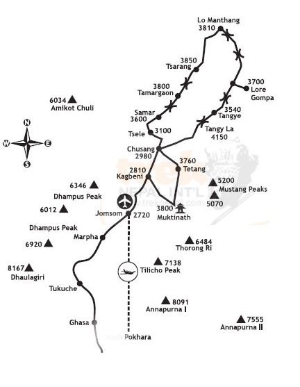
Itinerary
Day 01 Arrival in Kathmandu.
We are greeted at the airport by our local partner and get on the flight to Pokhara for. Transfer to hotel.
Day 02 Pokhara - Jomsom and Kagbeni (2810 m).
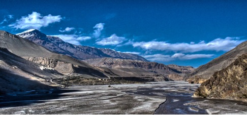
A small plane carrying us to the mountains in the morning. We fly low across the Kali Gandaki, the world's deepest valley, and 8000 meters high mountains on both sides. The view is magnificent; Machapuchare, Annapurnamassivet and Nilgiri to the right. To the left rises colossus Dhaulagiri 8167moh into the air. We land on the airstrip in Jhomsom 2700 meters, the administrative center of Mustang district. So far, but no longer, we may, using modern means of transport. From now on, only their own feet and any horse that can bring us further. In Eklibhatti, ca. 11 / 2 hour walk from Jhomsom, we eat lunch. Early in the afternoon we arrived in Kagbeni where we have our first camp.
Day 03 Kagbeni (2810 m) - Chusang (2963 m).
As far as the Kagbeni tourists have been allowed earlier. The narrow alleys and tunnels, irrigation canals and the large, red gompaen gives us a foretaste of what we have in store. Police checks that we have permission to enter the Upper Mustang. We stop in the village Tangbe to rest and eat lunch. Chusang lies like a green oasis beside the river, and here we turn up camp for the night. The rest of the day strolling around and we talk to the locals.
Day 04 Chusang (2963 m) - Samar (3290 m).
It's ascension to the village Chela. The culture is changing and becoming more Tibetan. We continue our ascent to the pass at about 3550m.oh The trail is wide and nice, and it is easy to walk. Height, we have noticed in that breath go a little heavier. From passport goes gradually down until we get to Samar on 3290 meters above sea level which is the current terminus. Samar is an important stopover for horse caravans.
Day 05 Samar (3290 m) - Giling (3600 m).
We put the high mountains behind us and move us in the open, dry and windswept landscape. From Samar goes up, we'll pass over two days, both approx. 3800 m before it again goes down to Giling of 3600 meters. Mustangiene is riding people. Increasingly, we meet men and women with braids and turquoise in their ears.
Day 06 Giling (3600 m) - Tram (3824 m).
The day starts with a long ascent to La Nya at 3950 meters. A little heavy it is, but on top you get rewarded. The view of Nilgiri, Tilicho Peak and Annapurna massif surpasses most. We continue over Ghemi La 3964 m before we stop for lunch in the village Ghemi. The stretch from here until the camp Tram is one of the best on the tour. The campsite is beautifully situated on the river outside the village.
Day 07 The Tram (3824 m) - Tsarang.
We continue through the valley of the incredibly exciting rock formations. Promote the Ghar Gompa we will have lunch, rest, and look us in the old monastery. Gompaen is decorated with paintings, statues and several large prayer wheels. The "tax", hundreds of carved and painted stones that are framed and exhibited on the walls. Ghar Gompa is one of the oldest still in use in Nepal.
Day 08 Tsarang - Lo Manthang (3700 m).
Today is our last leg towards the final goal and the turning point of the trip, Lo Manthang. With the high wall that surrounds the city, the king's palace, white and red temples, seems Lo Manthang large and impressive compared to the small villages we passed on the road. Behind the walls teem with life. Photo images are numerous and exotic. The networks are in Lo magic with the incessant sound of hundreds of horse bells.
Day 09 Lo Manthang (3700 m) - Horseback riding.
We rent horses and go on day trips to some of the villages north of Lo Manthang. There are several old and interesting monasteries and gompaer. We eat food for our packages and enjoy the scenery and folk life around us.
Day 10 Lo Manthang.
We use the day to visit temples and explore the city. Gompaene in Lo's from 1914 to 1500's and contains priceless cultural treasures. Chyodi Gompa is the only school in the monastery of Lo. Champa Lha - Kang and Tugchen Lha - Khang, with its art treasures are just the temples and shrines.
Day 11 Lo Manthang - Dri
We turn back and leave Lo Manthang. Back we have chosen a different route that takes us through interesting villages on the east side of the Kali Gandaki. These are areas that are rarely or never get visits from the outside world. We go first in the flat and easy terrain. Since we have a steep, wild and exciting descent to Dri that is as warm to the Kali Gandaki that they manage to get two crops a year.
Day 12 Dri - Tange.
In majestic surroundings, we follow the river a piece. After a while we leave the river and embarking on a long ascent. As always, the view from the top fantastic. Tange proves to be an idyllic oasis on the river bank.
Day 13 Tange - Pa (4060 m).
During the day when the tour's highest point, Pa at 4060 m above sea level where we camp just below the pass. Here is the only source of water between Tange and Tetang. The shepherds come with large goat herds that drinking your fill at one source that is reserved for animals. Do not include wash water today!
Day 14 Pa - Tetang.
Today it down, Tetang, located on a tributary of the Kali Gandaki.
Day 15 Tetang - Muktinath.
A long day of Tapla at 3993 meters to Muktinath. It feels like being back in civilization, even though we are one week from the nearest road. Here, the restaurants and guest houses in a row.
Day 16 Muktinath - Jomsom.
In the Hindu mythology, Mahabharata, written around 300 BC. Muktinath is mentioned. Hindu and Buddhist pilgrims have flocked here for centuries. Water is important in Hindu rituals and both Hindus and Buddhists Muktinath going to swim. We eat lunch in Eklibhatti and have our last camp in Jhomsom. Tonight is the farewell party with our Nepalese friends.
Day 17 Jomsom - Pokhara - Kathmandu.
The morning flight to Pokhara and then by plane to Kathmandu. Transfer to our hotel. The rest of the day at leisure.
Day 18 Kathmandu.
Reserve Days (in case of flight delays) at leisure in Kathmandu.
Day 19 Kathmandu.
Reserve Days (in case of flight delays) at leisure in Kathmandu.
Day 20 Kathmandu.
Sightseeing to Bhaktapur, the third largest city in the Kathmandu valley with most of the original architecture intact. Bhaktapur was the capital of the 1400-1600 figure. By Bagmatielven, 5 km from Kathmandu, is Pashupatinath, which is a pilgrimage place for Hindus. Shiva Temple here is the most important Hindu temple in Nepal. King of Nepal come here every time he going to travel to get the blessing. From Pashupatinath we go on to Boudanath where Buddhists gather. Here is the largest stupa in Nepal, it is actually one of the largest in the world. Boudanath is the religious center for Tibetans living in Nepal. The rest of the day and evening at leisure.
Day 21 Kathmandu - Pokhara.
Day on their own in Kathmandu
Day 22 Kathmandu Transfer to airport for departure.
The Presidents’ Trek I
INTRODUCTION:
This area is off the beaten track and offers magnificent panoramic views of the Dhaulagiri and Annapurna ranges, and of Manaslu and Himalchuli. We recommend it from mid October all the way through the season until May. The Pokhara valley itself gets quite hot in the late spring but temperatures on much of this route should remain pleasant and the bird life and spring flowers in bloom, including Rhododendron and white Michaelmas will add to the interest.
ITINERARY
Day 01 BHUMDI - Fly to Pokhara
Day 02 PANCHASE LEKH
Day 03 TILHAR
Day 04 BARA POKHARI
Day 05 SAI MANDHIR
Day 06 BHAISI KHARKA via JALJALA
Day 07 REST DAY
Day 08 BANTHANTI
Day 09 GHANDRUNG
Day 10 POTHANA
Day 11 POKHARA LAKE SIDE CAMP
Day 12 FLY POKHARA – KATHMANDU end of the trek
The Presidents’ Trek
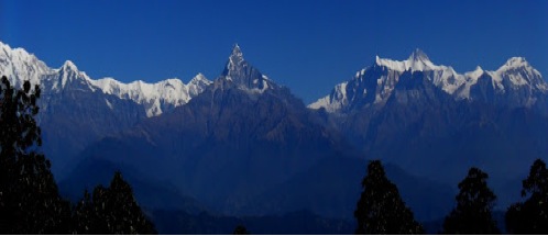
This area is off the beaten track and offers magnificent panoramic views of the Dhaulagiri and Annapurna ranges, and of Manaslu and Himalchuli. We recommend it from mid October all the way through the season until May. The Pokhara Valley itself gets quite hot in the late spring but temperatures on much of this route should remain pleasant and the bird life and spring flowers in bloom, including Rhododendron and White Michelia will add to the interest.
Normally a four or five day trek can be readily extended but the following is recommended as a standard five-day itinerary along the rolling foothills with panoramic view.
DEATAILED ITINERARY
Day 01:
Fly/drive to Pokhara. Start trek around mid-day with 20-minute drive south from Pokhara along the Tansen road to the start point at Thado Khola (stream). The route climbs away up the west bank before traversing left through the Chettri/Bahun village of Kalibang. On up through mixed farming country to Bhumdi (5000'/1525m). The ridge line offers fine views north to Machapuchare and Annapurna and east to the Manaslu Himal. Overnight at Bhumdi. (5249'/ 1600m) Time: about 2 ½ hours.
Day 02:
The panoramic views from this ridge are in many ways better than those obtained from the areas nearer the mountains offering an amazingly wide vista. The trail leads on up the ridge then leaving the scattered dwellings behind climbs through mixed vegetation before entering thick deciduous forest full of bird life, trees, orchids, and in spring time abundant flowers including rhododendrons and white michelia. The route lies through shady north facing slopes and is moist and dark leading to prolific plant growth. The trail traverses on west towards Panchase Lekh (8218'/2505m) before climbing up to the ridgeline where there is a Chautara (resting place). Shortly after this open ground is reached on the south facing slopes and fine lunch spot is ready, built in the form of a "Roman Fort" on deserted farming terraces. Half an hour walk leads to a distinctive 'bhanjyang' (ridge crossing point). Climb away west to the "Presidents' Camp" set high on hills immediately below Panchase Lekh. Time 6 - 7 hours.
Day 03:
An early morning climb of Panchase Lekh is well worthwhile. There is a shrine near the summit and a small lake on the west side of the hill. Stunning views can be seen of not only the Himalayas but also across the broad sweep of the foothills in all directions. After a late breakfast the route traverses to Panchase Deorali where there are scattered dwellings before descending through farming country towards the lake. Overnight at Bhadaure – 1700m. Time: about 4 - 5 hours from the Presidents' Campsite. 7 - 8 hours including Panchase Lekh climb.
Day 04:
Continue the trek via Naudada, Kare and "Austrian" camp to Dhampus – (5577'/ 1700m) – Overnight here.
Day 05:
After a relaxed morning we begin trekking mostly downhill, through the forest to Phedi, about 1 and half hours. Our vehicle will meet and drive us back to Pokhara (about 40 minutes). Overnight in Pokhara or take a flight or drive back to Kathmandu.
Syaglung Trek (Annapurna Panorama)
The Prince of Wales first used this route in 1980. The trek starts after about 20 minutes drive from Pokhara to Bijyapur Khola and leads up onto a ridgeline through Brahmin and Chettri villages in the beginning and goes through the villages mainly populated by Gurungs afterwards. The Gurungs are renowned as one of the leading martial races in Nepal. Since the mid 19th century they have served with pride in the Nepalese, British and Indian Armies. Their homeland is the southern flanks of the Annapurna range. They tend to live high up on relatively steep slopes, among maize and millet fields and from these places cultivate rice fields on the valley floor. The Gurungs of West Nepal, originating from the North and following Buddhist customs have pronounced Mongol features. They are normally short but stocky.
The scene from the first campsite (KALIKATHAN) overlooking the entire Pokhara valley offers mountain views of the beautiful Machapuchare, to the north of Pokhara, the mighty Annapurna range and Lamjung Himal, Manaslu and Himalchuli, to the west. On the second day the ridgeline leads eastwards before a sharp climb up to the Gurung village of SYAGLUNG – the campsite is just above the village, on a meadow. The third day is to the CHISAPANI hill, another hill to the southwest of Syaglung. Second half of the walk is through forests and uphill. Campsite is below the shrine. The last day is almost downhill to the bottom of the foothills, through the rice fields then a little uphill to SUNDARE DANDA – a ridgeline between the two big lakes – RUPA and BEGNAS. The trail then drops to a roadhead where transport meets for the drive to Pokhara – about 3km away.
Day 1 KALIKATHAN
Day 2 SYAGLUNG
Day 3 CHISAPANI
Day 4 POKHARA - Hotel or camp by Lakeside.
Upper Dolpo to Jomsom
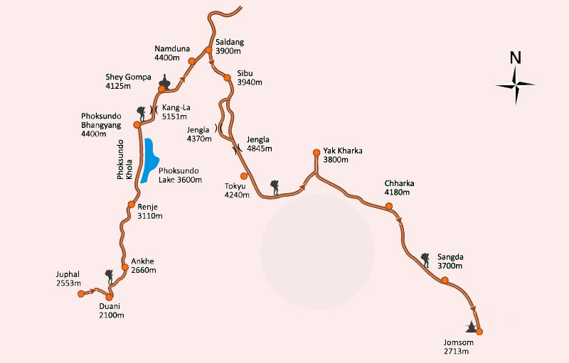
Day 1
Arrival KTM
Day 2 KTM:
Preparations, permits etc.
Day 3
Fly to Nepalgunj, the largest city in western Nepal, the heart of the Terai, near the Indian border. Overnight in guest house.
Day 4
Fly to Nepalgunj, the largest city in western Nepal, the heart of the Terai, near the Indian border. Overnight in guest house.
Day 5 Dunaï - Sekpa (2700 m) .
Rise in the valley of the Suli Gad, who was born in Lake Phoksumdo. Gradual rise in the balcony to the hamlet of Sekpa (2700 m) among crops and forest. 4:30 hrs walk, climb 760 meters + / - 150 meters. Overnight camp.
Day 6 Sekpa - Sumdo (3000 m) .
The path runs along the Suli Gad still mainly in the forest. A passage in the balcony will reveal beautiful views of the massive Kanjiroba. Camp at 3000 m. at Sumdo 4:30 hrs to walk 810 km, altitude 375 meters +. Overnight camp.
Day 7 Sumdo - Ringmo - Phoksumdo (3600 m)
We reach the confluence of the Suli Gad and Pumgma Khola. Another hour in the forest, up the course of the Pumgma Khola. The vegetation changes, conifers become the majority. We enter the pastures and soon discover Palmo, a winter village residents of Ringmo. From there, we attack a steep climb .. Soon is the beautiful waterfall (300 meters high, one of the highest of Nepal), serving as a spillway at Lake Phoksumdo. Passage of a shoulder (3860 m) and gentle slopes toward the village of Ringmo whose houses stand out in a forest of pine and juniper trees on the banks of the lake waters deep blue mountains. Afternoon for rest and exploration in the area, visit the Bönpo monastery on the lake shore and chortens tan and white with distinctive architecture. 3:30 walk, climb 665 meters + / - 200 meters. Overnight camp.
Day 8 Phoksumdo Lake – Forest camp (3800 m) .
We enter the upper Dolpo and leave the area "allowed" by the classic trekking permit.The path along the lake to the magnificent turquoise, first on the banks, then quickly Balcony: up and down, sometimes delicate passages remind us of the sequence so impressive of the "Childhood of a Leader" of the film Eric Vali (3:30 walk). Leaving the lake, we ascend the Phoksumdo Khola and camp in the forest at the confluence of its tributary that will lead us to the Ganda La. We are at the foot of Kanjeralwa, a nice solid ice 6612 m. Bush camp at 3800 m. 6 hours walk, climb 645 meters + / - 540 meters. Overnight camp.
Day 9 Trek to d Ganda La (4700 m) B.C.
We go up the stream in a gorge crossing many times, finally reaching the foot of the pass that we are no longer separated by large slopes. Camp at 4700 meters and rest for acclimatization. altitude + 935 m / - 55 meters. Overnight camp.
Day 10 Cross Ganda La - Shey Gompa (4125 m)
About 2 hours to the summit (5150 m): cairns and prayer flags greet us ... the emotion of a landscape discovered by David Snellgrove and Peter Matthiessen .- 'kyi kyi lha Gyalo na na "(demons are defeated, the victorious gods) one exclaims in Tibetan root of the local dialect. We descend slowly along the river and reach Shey Gompa. Made famous by the stories of David Snellgrove and Peter Matthiessen (The Snow Leopard), Shey Gompa was founded, say the Dolpo-Pa, a great yogi, Drutob Yeshe Senge, who arrived in these places on a leopard wheel. During his meditations, he built a Chorten crystal near a small mountain lake: the pilgrims still collect rock crystals. Shey's name comes from elsewhere Shel: crystal in Tibetan. The famous "Crystal Mountain" is a white pyramid, sacred throughout the Dolpo, which dominates the neck Phoksumdo. The small monastery karma-kaguypa is busy at certain times of the year in late spring, it is the seat of a festival bringing together all the Dolpo, at which the pilgrims make a trip ritual of Crystal Mountain. (3 hours walk). By late afternoon, we visit Tsakhang, the monastery of retirement in a cliff hanging (2 hours hiking). The monks have banned hunting of many animals roam the valley of Shey, including the snow leopard! Camp in the monastery at 4210 m). 3 hours walk, climb 685 meters + / - 975 meters. Overnight camp.
Day 11 Shey Gompa - Nam Khong (4230 m) .
We leave Shey Gompa, go along the wide valley to the east, then go back to the Nam Khong-La (4925 m) meadows grazed by herders living in tents. The summit is revealed an exceptional view of the high plateaus and peaks of Tibet, close (4 pm to climb). We descend quickly camp near Nam Khong and his recently restored monastery (4230 m). 2:30 slope.Village built on both sides of a gorge, the ancient monastery clinging to the cliff Kagyu, gave his name to all that part of Dolpo. 6:30 walk, climb 795 meters + / - 245 meters. Overnight in camp.
Day 12 Nam Khong - Saldang (3900 m) .
Nam Khong, we climb to reach an upper balcony. Then, after crossing a shoulder at 4400 m, we descend on Saldang (3750 m), village Dolpo-pa typical houses scattered among the terraces on a hill. In the afternoon, stroll through the village. 3:30 walk, climb 460 meters + / - 740 meters. Overnight camp.
Day 13 Saldang - Yangser - Camp near Nyisal (3800 m) .
We go north along the valley of Nam Khong downstream: at its confluence with the Panzang Chu is the village of Nyisal dominated by the monastery of Yangsi. Our team sets up camp and we go to the monastery in the afternoon. This ancient Sakya gompa, became Nyingma, is particularly impressive, lost deep in the Himalayas: a strong testimony of the religious fervor of the Dolpo-pa. 4 hours walk. Overnight camp
Day 14 Nyisal - Mu (4100 m) .
A path strewn with many walls and chortens prayer leads us to Mu, the northernmost town of Dolpo, the gateway to reach the large village of Shimen. Very wild place that combines Dolpo - pa and Kamp came from Tibet. The people are specialists in caravan trade. Camp at 4100 m. 5 hours walk. Overnight camp
Day 15 Mu - Shimen (3925 m).
Although there is a path that connects to Shimen Mu, but it is usable in winter. So we have to go through a shoulder to over 5000 m. But the view is the appointment, as close to Tibet than to the south of Dolpo. Arrival in Shimen, a small town with beautiful terraces ideally placed in an open valley. Depending on the availabilty of the place of bivouac, we can camp near the village as well as the next flat area about 1 hour from here to 4010 m. 5 hours walk.Overnight camp
Day 16 Shimen - Thingkiyu (4145 m) .
Day contour passing through the hamlet of Phal is one of the favorite passages Dolpo-pa to travel to Tibet. The ability to cross the caravan is great. Between fields and banks of river we reach Thingkiyu, where religious fervor is visible. Camp at 4135 m. 5:30 walk, climb 400 meters + / - 180 meters. Overnight in tents
Day 17 Thingkiyu - Shela La B.C.
Valley, the Mecca caravans crossing divides into two branches, Charka and Do. In the middle of "Tea shop" and yaks we reach the foot of the pass of Shela La (5060 m). Camp at 4900 m. 7 hours walk, climb 800 meters + / - 50 meters. Overnight camp
Day 18 Trek near Dö, Tarap (4050 m)
We descend into the valley of C, Tarap, (4050 m), "the valley of excellent horses," which made known the Dolpo. This is the most populous of the region: Tok Kyu encompasses the villages built on both sides of the Tarap Chu, Dö those of the confluence of the Tarap Chu Chu and Doro. Buddhist temples and shrines and Bonpos line the two valleys, the women wear beautiful dresses sometimes money. 6 hours walk, climb 530 m + / - 950 meters..Overnight camp.
Day 19 Dho Tarap valey – Camp Tsharka (4550 m) B.C.
Arrives at the confluence, we head east and begin the ascent of Doro Chu. We pass near the monastery Bon Ship Chhok, then cross the hamlet of Ro Do, the last Tarap Valley. In the gorge, we reach a grassy plateau at the top of a talus at the foot of the first pass that separates us from Tshark. 4 hours walk, climb 715 m + / - 70 meters. Overnight camp.
Day 20
One of the wildest days of the route. We go back to first pass Tshark (5300 m) in 2 hrs.Great view of the Dhaulagiri V and III. We go down to lunch by the river, then go back to the foot of the second pass, along a wide valley. 6 hours walk, climb 810 meters + / - 720 meters.Overnight camp
Day 21
Rapid rise in the second Tshark Pass (4880 m) and descent to the village of the same name. Very different from other villages Dolpo-pa, Tshark looks like a fort with its tall buildings and temples grouped into walls overlooking the River. Visit the village. We go back in the tumultuous Barbung Khola and find a camp at 4330 meters upstream 6:30 walk, climb 670 meters + / - 980 meters. Overnight camp.
Day 22
Trek up to direction of Sangda pass. We continue to go back in the river to get a ford upstream. We pass a grassy plateau, with a large house, then find a way possible. From here we climb up grassy slopes by a wide valley. 4 hours walk, climb 595 meters + / - 165 meters. Overnight camp.
Day 23
Cross Sangda pass 5240 mtr. The climb is gentle and progressive until Sangda La. First green, it becomes mineral to the top of the pass (5420 m). A quick descent to the shelter for lunch, and we continue in a wilderness setting to reach a final shoulder (5000 m). For a quick and steep descent, we reach a grassy plateau to camp at 4305 m, in front of Sangda. 6 hours walk, climb 710 meters + / - 1115 meters. Overnight camp
Day 24
Camp near the river. We descend to the river crossing the new bridge and go up on Sangda (there are two villages on each side of the valley, one winter, one summer). Picnic at Sangda, then a good climb we reach the first torrent to install our camp at night. 6 hours walk, climb 940 meters + / - 1065 meters. Overnight camp
Day 25
Trek to Jomsom. We cross several shoulders and neck in 4150, 4320 and 4020 m. Along the way we pass beautiful herds of yaks and enjoy a beautiful view of (if the weather is nice!). We reach the village of Phallak and begin our descent and the Kali Gandaki. We visit Dangar Dzong village opens to the Mustang on one side, the Kali Gandaki low on the other. The valley of the Kali Gandaki is the world's largest, dominated by two peaks of 8000 m: Annapurna and Dhaulagiri. After a final Shoulder (3700 m), we descend quickly through the debris to Jomosom (2713 m). Festive evening with our team of porters, cooks and Sherpas. 6 hours walk, climb 705 meters + / - 2085 meters. Overnight camp
Day 26
Fly to Pokhara then onto KTM.
Machhapuchure Foothills
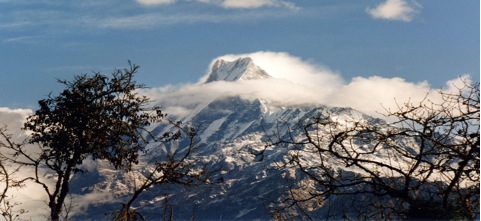
Introduction:
A short but rather hard trek which gets away from the crowded trails which dominate the popular routes in Annapurna area, offers a quick climb to altitude, rhododendron forests, high grazing pastures possibly the finest view of all for the Annapurna massif, contrasted with the quiet beauty of the low lying Seti Valley and river gorge.
Day 01 MARDI PUL (3440'/1050m):
A short drive up through the length of Pokhara town leads to the Shining Hospital at the northern end. The trek starts out up the busy trail to Hyangjo, past the new irrigation project. Here will be met fellow trekkers, local people traveling in and out to Pokhara, pony trains heading to or from Mustang, and old jeeps on the rough road to Suikhet at the top end of the Yamdi Khola valley. 15 minutes after passing the original Tibetan Refugee Camp the trail to Mardi Pul leads right across paddy fields following the west bank of the Seti Khola. After passing the confluence of the Mardi and Seti rivers the trail drops down to the river and a small bridge leads across to the village. There is an excellent campsite on the west bank of the river just above the bridge. Time 3 hours.
Day 02 ODANE HILL (8232'/2510m):
The trail follows the east bank of the Mardi upstream before turning right up the hill to the Gurung village of Riban. Due to the shortage of water higher up an early lunch is advisable. Afterwards be prepared for a hard but rewarding afternoon. The trail climbs away from the village to a Chautara (resting place) and a few minutes above divides. The right fork leads up to a few cowsheds. After being steep the trail now becomes even steeper as it climbs through bamboo towards a massive dominating slab of gray rock face. Then it bears round left on to the ridge and into rhododendron country. However the ridgeline offers little respite but compensates with the ever-developing views of the surrounding country. Through a small clearing on a high point of the ridgeline – Odane Hill 5000'/1524m higher than the start point for the day. Time 7 ½ hours.
Day 03 KUMAI (10,000'/3049m):
The trail follows the ridgeline but beware of the odd false trail than can deceive and lead the unsuspecting off the route! The previous day's work is rewarded with cool mountain air and stunning views of Macahpuchare (22,950') straight ahead of Annapurna I (26,495') to the west, towering over Annapurna South (23, 527') with its ridgeline leading to Hiunchuli (20,782'), one of the most difficult trekking peaks. To the east lies the massive granite peak of Annapurna II (26,033'), knob shape of Annapurna IV (24, 682') and the elephant like hulk of the Lamjung Himal (22, 914'), farther east the Manaslu range with Manaslu I (26,751') lying to the north of Peak 29 and the more prominent shape of Himalchuli (24, 731') and Baudha Himal (21, 884'). Given that it is also possible to get the glimpse of the summit of Dhaulagiri (26,787') away to the northwest, this means that three of the world's 14 peaks over 26, 240' or 8000m are in view. Water is in short supply and normally a packed lunch will be eaten along the way. A short sharp climb leaves the main forest behind and leads to a fine camping area in alpine grassland country. Time 6 ½ hours.
Day 04 KUMAI:
About 1 ½ hours above camp lies the high grazing country called Khorchon at aound 12,000'/3658m, and an early morning trip up to explore the area is well worthwhile. Watch out for Danfe pheasants – the National bird of Nepal and other wildlife in the area. Most might welcome an afternoon's rest back in camp but the more ambitious could explore the high country leading up towards the beautiful south face of Machapuchare and the 'trekking peak' of Mardi Himal (18,318') rising out of the southwest ridge of Machapuchare.
Day 05 GHACHOK (3500'/1067m):
Most of the altitude gained is lost during the return back down the ridge and the descent to the valley floor that follows. Just before reaching Odane Hill a little path off the east flank of the ridgeline leads to a rapid descent to grazing land and a good lunch spot at Hile. Afterwards a steep descent leads to the prosperous farming village of Chachok lying in the Seti river valley. Time 7 ½ hours.
Day 06 CHYANGLUNG HILL (6000'/1829m):
The Seti river craves an outstanding gorge through the valley and the walk north on the west bank high above the river is a delightful contrast with all that has gone before. The little bridge of Diprang is reached after about 1-½ hours and there are hot springs in the area. The climb to Chyanglung Hill is pleasant and from the very lovely setting of the campsite there are views of the Annapurna Range, whilst being very different from those seen earlier are equally as fine in their way. Time 6 hours.
Day 07 POKHARA (2994'/913m):
Back down through the forest. Ghachok village on the opposite bank of the river is passed after about 3 hours. The walk back into Pokhara inevitably brings people and building, roads, vehicles a rather sudden cultural shock after the peace and tranquility of the previous six days. Transport meets at the top end of the town to return to Pokhara – where the trek ends.
Annapurna Massif Circuit
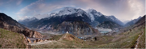
Originally many of these treks starts from the village of Dumre on the Kathmandu Pokhara road but there is now a Besisahar. We feel that for a true around Annapurna trek, it should start and finish in Pokhara itself and certainly during the early days of this route, before reaching the Marsyangdi valley, we will meet few if any other trekkers. However, once on the main trail up through Manang during the popular trekking months of Oct/Nov and late Mar/Apr, there are many people attracted to this route, which is one of the finest long treks in Nepal.
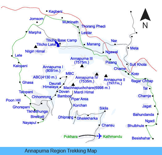
DETAIL ITINERARY
Day 01 KALIKASTHAN (1524m):
If arriving by air, transport is provided for the 20 minutes drive out to the Bijaypur Khola on the route towards Kathmandu to the trek start point. Alternatively, if by road then coming from Kathmandu there is no need to go right into Pokhara and the vehicle will deliver clients to the start point itself. This first three hours trek up the hill to Kalikathan winding up through Chettri/Bahun villages and past shaded Chautaras (resting places) the campsite is reached with a final little scramble up from the main route. It sits on the western edge of this ridge and offers some of the finest views of the Annapurnas, Lamjung Himal, Manaslu and Huinchuli range.
Day 02 DOBHAN ON THE MADI KHOLA (762m):
A delightful morning's walking east along the ridge through mixed farming leads to the little village of Lipyani. Lunch will probably be taken before reaching this village and in the village itself the route drops away north through some quite heavily wooded country before a steep 475m descent leafs to a long suspension bridge over the Madi Khola itself. There are some fine campsites close to the river – good for swimming in the warm seasons and a little settlement of temporary huts and a couple of houses at the confluence of the Madi Khola and Rudi Khola near where we camp.
Day 03 Beyond SALMA (1585m):
The trail leads along the bank of Rudi Khola, an attractive river valley and after the odd up and down bypass small gorge areas, the trail crosses the river and there is a steep climb for 1-½ hours or so. Near the top of the hill the trail traverses north and the ascent eases. There are some good spots for lunch around here and the mountain views to the north are again excellent. It is a delightful afternoon's walk through miles of terraced fields. There will be added interest if it is harvest time with almost the whole family in the field day long either planting or harvesting dependent on the time of the year. The large Bahun village of Salma is reached after a couple of hours and lie attractively on the ridgeline. Much of the architecture of the local houses is typical Gurung but there are surprisingly few Gurungs actually living in the village area. Dependant on how the day has gone there are campsites near the village or another thirty minutes or so on in the small village of Gamrang Besi where there are some very attractive houses and farms.
Day 04 BAGLUNG PANI (1524m):
Descend through cultivated terraces to the Midam Khola and then start s fairly long and arduous ascent up to a very fine camping area at Baglung Pani itself. Just north of here lies the large Gurung village of Ghanpokhara which is about 1 ½ hours away but in view of the length of the trekking route and this day in particular we think Baglung Pani will be the best camping spot offering mountain views as good as obtainable from Ghanpokhara, particularly now to the east across to Manaslu, Himalchuli and Peak 29.
Day 05 BHULBHULE (853m):
The trail, which is a good one descends fairly gradually towards the village of Khudo on the Marsyangdi river and here we join both the main trade and trekking routes and things will suddenly be much busier. Opposite Khudi (on the west bank of the river) where the Khudi Khola enters the main river, the Marsyangdi swings north. The trail rises high above the river and round the corner revealing further views of Himalchuli and Peak 29 now verr near and rising massively more than 22000'/6700m above camp near the river of Bhulbhule.
Day 06 SYANGE (921m):
Continue up east bank of river, crossing Madi Khola bridge after 1-½ hours. Climb to Bahundada ridge (4300'/1310m) in about 2 hours. Descend towards river once again and reach vicinity of bridge at Syange after another 2 ½ hours. Total about 6.15 hours. Syange is the northern limit of rice cultivation in the Marsyangdi valley.
Day 07 TAL (1646m):
Trail now climbs slowly into increasingly narrow canyon. Cross river on good suspension bridge bear Chamcha and continue ascent past canyon descending from rock barriers of Peak 29 and Namum Bhanjyang. Camp at Tal, the gateway to Manang District a beautiful flat meadow with several Tibetan houses and a splendid waterfall coming off the lower reaches of Peak 29. This is a superb campsite. The trail passes Jagat after 1-½ hours and Chamcha after another 1-½ hours. Tal is another 2 hours, short day but all climbing.
Day 08 TEMUNG Meadows (2591m):
Ascend east bank of Marsyangdi through main gorge. The trail here is at times cut out of vertical cliffs. Cross to west side of the river at Dharapani 6200' just south of Thonje, the confluence of Marsyangdi and Dudh Khola (the later coming from Larkya Pass, two days northeast). Do not cross river to Thonje but turn west and follow trail ascending on south side of Marsyangdi through forest and meadows for about one hour then climb steeply towards Namun Bhanjyang to Temung meadows, a series of lush pastures perched high above the river. There are excellent views of Manaslu and the peaks situated above the Larkya Pass.
Day 09 KUPAR (2591m):
Near Chame, the headquarters of Manang District trail runs diagonally from Temung through Thenchok village (286m) and down towards river to Kupar which lies above the junction of the Marsyangdi with the Nar river, coming in from the north. Police check point here. Coming from Temung this is a short day of only 4 hours.
Day 10 PISANG (3354m):
Pass Chame after 1 ½ hour and cross bridge to north side of river near horticultural apple farm at Brathang (2744m). The covered bridge with a door in the middle allegedly was used to prevent robbers from the north coming into the lower Marsyangdi. Begin spectacular ascent to Pisang. Before Pisang the valley makes a dog's leg turn. This begins the transition into the rain shadow experienced between Ghasa and Tukuche in the Kali Gandaki. Walk through a magnificent forest with the Marsyangdi in full cry below, gaining momentum to break its way through the line of main Himalayan range between Annapurna II and Mansalu. There is a choice of campsites at Pisang below the village, either south or north of the river, or about ½ hour before in the pleasant wooded country, sheltered from the prevailing wind.
Day 11 BRAGA (3506m):
Beautiful day, on easy terrain through forest to small ridge at 11,300'/3445m. Below and stretching into the distance is the upper Manang valley. The southern tier of this valley is walled by Annapurna II, III, IV – 7936m, 7551m and 7522m respectively, Gangapurna 7450m and Glacier Dome 7070m to the west and visible just south of distant sharp rock peak is the great barrier and the basin containing Tilicho Lake 4920m and beyond, Tilicho Peak 7135m is out of view at the head of the valley. To the north is Thorong La 5396m and Thorungtse ridge of 20 to 22,000' peaks. Descending from this viewpoint, the path crosses a plain and passed Hongde airstrip 3415m. Further on, the Sabji Khola is passed and Braga is reached. Braga is Cliffside village with several monasteries and excellent campsites in the fields below village.
Day 12 BRAGA:
It is essential to spend time on acclimatization in the area. There are splendid views of peaks from both Braga and Manang. Manang is a large village situated on a rise immediately across from a huge glacier descending from Glacier Dome and Gangapurna. A beautiful emerald lake lies at its foot. Possible side trips to a lake about 3 hours north of Braga at 4848m, to the main Manang Gompa, or to Khangsar 3704m on the trail to Tilicho Lake.
Day 13 CHAKADUNGA (3963m):
A short day for acclimatization. About 4 hours from Braga, passing Manang and Thankey villages. A side trip up the stream following down from the west Chulu peaks can be done in the afternoon.
Day 14 THORONG PHEDI (4405m):
The trail turns northwest up the tributary valley of the Jargeng Khola. It is sometimes possible to see herds of blue mountain sheep along the cliffs. We cross a covered cantilevered bridge and ascend to Phedi, the last campsite before the pass.
Day 15 MUKTINATH (3810m):
Ascend steeply for 3 hours to rock ledge and notch at 4950m then along an undulating trail to the level top of Thorong La 5396m. Views of the Annapurna range to the south and Mukut Himal bordering Dolpo to the west. The peak immediately north of the Pass is Thorongtse, to the south is an unnamed peak of 6625m. Descend into Mustang, a steep downhill trail for three hours to Muktinath – splendid views of Dhaulagiri and Tukuche peak are seen. Muktinath is one of the most important pilgrimage sites for Nepali Hindus. It is mentioned in the classic Indian epic, the Mahabharata, and we may see pilgrims bathing in the holy water flowing from the 108 carved spouts surrounding the Vishnu Temple in a grove of sacred poplars. Muktinath is also home to many ethnic Tibetans and is holly to Buddhists as well, particularly for the temple in which fire miraculously burns in a stream of water!
Day 16 MARPHA (2670m):
Descend gradually through fields and popular groves, then steeply into the Kali Gandaki River valley, reaching the valley floor at Eklaibhatti (lone hut) at 2774m. Follow the valley southward to the headquarters of Mustang District, Jomsom 2713m a large settlement with a STOL airstrip, police station and bank. The Kali Gandaki here is called the Thak Khola, from the ethnic group of the Thakalis, many of whom live in this area. Enterprising and ambitious the Thakalis formerly dominated salt trade with Tibet in this region and after its collapse diversified into running hotels along the trek route, construction and other business. We continue into Marpha, a lovely village of whitewashed houses and productive fields.
Day 17 KALOPANI (2530m):
Continue our transition from the Himalayan rain shadow into coniferous forest, we return to the main river valley and onto the villages of Kalopani and Lete, which string out and merge over a distance of two miles through an area of beautiful pine woods and grassy meadows.
Day 18 TATOPANI (1189m):
A lovely day with another major transition into subtropical vegetation and the return of water buffalo, banyan trees and poinsettias. The trail follows high above the river through a narrow gorge, descending again to across a bridge near a spectacular waterfall where we usually stop for lunch. We leave Thakali country at Ghasa and enter an area of mixed Hindus, high cast Brahmin and Chettri hill farmers and hill tribes Gurung and Magars. In Tatopani (Hot Water) there are natural hot water springs.
Day 19 DEORALI (2713m):
A hard days work ahead with an altitude gain of 1524m to be made. The trail initially follows the Ghorapani route before branching off left into much less traveled country. The path follows approximately up the line linking the Ghorapani area to that of Ghandrung crosses the Deorali Pass and the trail reaches the crest east of the pass. There are some fine campsites available in the area.
Day 20 GHANDRUK (1920m):
This area offers some of the finest trekking in Nepal. The Annapurna range and Machapuchare dominates the mountain views though glimpses further east to Lamjung Himal and the Manaslu range are also possible. The village of Ghandrung is reached through its excellent farming land and the generations of its sons who have sent and received pay and pensions from the British and Indian Gurkha armies. Time spent in a sidewalk through the village on the route towards Chomrong and the Annapurna Sanctuary is rewarded with the most attractive scenes of rural village like in the hills of Nepal.
Day 21 Forest Camp (above DHAMPUS) 1950m:
A hand glider is really required for the first leg of this day's journey. The close view across the Modi valley to Landrung 1610m is intercepted by a 600m descent to the river valley and steep climb the other side. Then the trail traverses through farmland south high above the river before climbing through forest and crossing one of Machapuchare's many ridges and dropping down to a fine camp set in a clearing in the forest. From the edge of the site there are distant views down to Pokhara's Phewa Tal (lake) and the foothills of Nepal fade into the haze of the Indian plains far to the south.
Day 22 POKHARA (915m) Lakeside camp:
The return via the Yamdi Khola is not recommended unless people wish to get into Pokhara early and decide to use the services of the beaten up old jeeps that bump their way down the riverbed. It is possible to hire a whole jeep but we recommend dismounting and walking down the step and potentially dangerous hill below the Tibetan camp at Hyenja. For those wanting to walk back to Pokhara, either drops down to the north side of Dhampus into the Mardi Khola valley. A long walk along the valley floor leads to the little village of Mardi Pul from where the trail leads back to Hyenja and then a final hour back to the northern end of Pokhara where transport can be arranged to drive down to the lake camp. Probably better though is via Naudanda and the Kaski ridge to the south, all the wat along to Sarangkot on the south side of which is a steep little path and it’s a bit of a scramble down to the side of the Phewa lake near which we camp.
Day 23 The end of the trek.
Breakfast and then either to the airport for the flight to Kathmandu or a return by road, which takes about 6 hours.
Annapurna Foothills
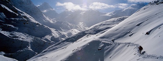
Day01 Fly/drive to Pokhara.
The trek starts with a 20-minute drive south from Pokhara along the Tansen road to the start point at Thare Khola. The route climbs up the northern flank of the ridge with the first night camp near Bhumdi, height around 5000'/1525m or at Lodges..
Day 02
Excellent panoramic views from the ridge as we traverse west soon leaving behind scattered dwellings and entering thick deciduous forest full of bird life, tree orchids and in springtime the area should be very good for flowers. The route lies through a shady north-facing slope traversing towards Panchase Lekh (8825'/2508m) before climbing up onto the ridgeline, now across the south-facing slope to a fine lunch spot before half an hour of "jungle bashing" leads to a distinctive Bhanjyang (ridge crossing point). The route climbs away west to the campsite high on a hilltop below Panchase Lekh – height around 7000'/2310m / Lodges.
Day 03
We recommend an early climb of Panchase Lekh for exploration and a panoramic view, which must certainly be one of the finest in the whole of this area. After an early lunch back in camp, the route leads up to the ridgeline, which runs north from Panchase Lekh and follows this down through forest before turning west towards Chitre. O/N at Camp or at Lodge.
Day 04
We traverse gradually losing altitude through mixed forest and farmland towards the Modi Khola. There is steep descent down to the village of Dobila where a bridge crosses the river the drains the Annapurna Sanctuary to the north and then steady climb leads us up to a campsite near Bisaula at 6000'/1825m. O/N at Camp or at Lodge.
Day 05
The ascent continues as we climb up towards the ridgeline. Crossing this we meet the main route coming up from the town of Kusma lying far below to the south. Following along this ridgeline trough rhododendron and fir there are marvelous views away to the west down into the lower reaches of the Kali Gandaki valley and across to line after line of foothills fading into the haze to the west. There are few settlements along here but we are entering real Pun country and closer to Thare the forest begins to thin out leading to fine open farming country with attractive solid built houses. The slate in this area if of extremely fine quality and used for the roofing of most of the houses – camp near Thare. O/N at Camp or at Lodge.
Day 06
This offers one of the finest days of trekking in Nepal. Leaving Thare care needs to be taken to establish the shortcut route leading over towards Ghorepani that crosses the western flanks of the very large Poon Hill feature. After about 1 ½ hours a ridgeline is reached with a high a further 20 minutes away which offers the most outstanding views of the Dhaulagiri Himal with Tukuche Peak further north and then across to the east of the Kali Gandaki valley the Tilicho ridgeline, Annapurna I, Fang, Annapurna South and an unusual view of Machapuchare (the fishtail). On a clear day further away to the east can be seen Lamjung Himal, Himalchuli, Ganesh Himal and it is even possible to see Gaurishanker far to the east past Kathmandu. There is good lunch spot above Nangiri before a descent and steep climb leads onto another ridgeline. The route climbs away through a mixed forest of holly and oak and then through hemlock and ever thickening rhododendrons. There is a delightful campsite in the middle of the forest with Dhaulagiri clearly framed to the north – altitude about 8500'/2590m. O/N at Camp or at Lodge.
Day 07
The route continues on through the forest before crossing the Poon Hill feature at about 10,000 feet and visit to the more popular trekkers' route Poon Hill feature is possible before dropping down into the over grown teahouse village of Ghorepani. It is doubtful is any other trekkers will have been met on this whole route before arrival at Ghorepani. However, after lunch it is possible to escape a good many of them by climbing away west over the Deorali pass – camp at around 9000'/2740m. O/N at Camp or at Lodge.
Day 08
Aside from the one or two rather scruffy settlements that have developed to meet the requirements of the backpackers this is another wonderful days of trekking. The route down the west side of the Deorali Pass can be slippery during the winter if snow is lying around and there are icy patches near the waterfalls. There are some marvelous viewpoints as the trek now approaches close to Machapuchare and the southern flanks of the Annapurna before the trail gradually descends through forest to the prosperous village of Ghangdruk (6297'/1920m), a Gurung village. Ghangdruk owes its wealth to the fine farmland it possesses and many generations of its young men who have gone off to serve in the Nepalese, Indian and British Armies. O/N at Camp or at Lodge.
Day 09
As one gazes across at Landrung, a little village lying on the far side of the Modi Khola, thoughts of how useful a hand glider would be are hard to dispel. The 1500'/450m descent to the bridge crossing the river is followed by a 1000'/300m climb to the village of Landrung. The reward is a pleasant contour south high above the river before the trail turns up through rhododendron forest, crosses a ridge and then drops down to our campsite set in the forest at 6400'/1590m. O/N at Camp or at Lodge.
Day 10
The mountain views from here are superb and down to the south still apparently far away lay the Phewa Tal and further to the south the foothills of Nepal roll away towards the Indian plains. The return to Pokhara from here is best by dropping down into the Mardi Khola valley lying on the north side of the ridge. The longish walk down the valley leads to the little village of Mardi Pul close to the point where the Mardi River joins the Seti River. Then through paddy fields and scattered houses to the Tibetan Refugee Camp and a final one-hour plod back into the northern limits of Pokhara town. We prefer this routing to the more popular one, which drops down from Dhampus south into the Yamdi Khola. There are bumpy jeeps, which rattle into Pokhara down the riverbed from Suikhet and those who wish for an early return to Pokhara could consider hiring a jeep privately for their party. If you do so, advise everybody to get out and walk down the steep slope below the Tibetan Refugee Camp, but otherwise it is an effective if rough way of getting back to Pokhara quickly. Certainly after a 10-day trek the walk down the rather dry dusty Yamdi Khola valley is not a very attractive way of finishing a trek. If the Mardi valley option is taken Pokhara will be reached in about 3 o'clock in the afternoon, or if the option of jeeps is taken then it is possible to be in Pokhara at about 11 o'clock, but in any event not early enough to rely on catching a flight back to Kathmandu on that day. Spend the night in a Hotel or in a camp by the lake. O/N at Camp or at Lodge.


