Langtang – Gosaikund – Helambu
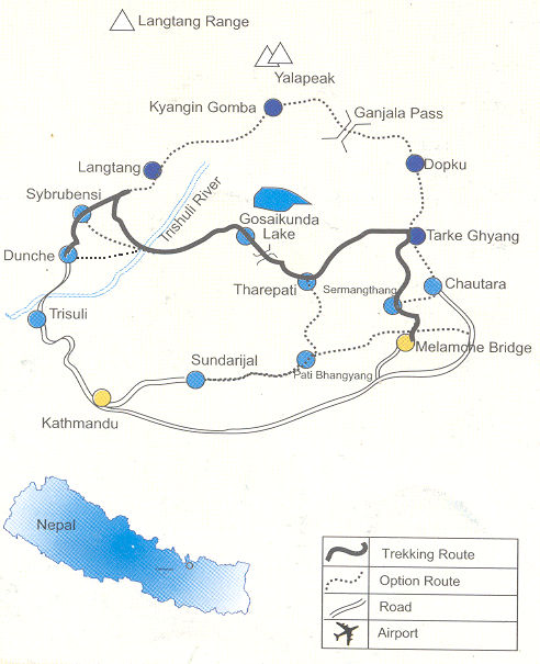
The Langtang valley is located almost directly north of the Kathmandu valley, close to the border with Tibet. It is bordered on the north by the main crest of the Himalayas, dominated by Langtang Lirung (7245m), the highest peak in the area. To the south are the Chimse Dada (ridge), crossed by Ganja La pass (5122m) and the Dorje Himal culminating in Dorje Lakpa (6989m).
The approach to Langtang from Kathmandu is by the Pasang Lhamu road to Dhunche and Syabrubesi. The trek is up the narrow Langtang gorge passing through dense forest of oak, birch and pine. Further on the valley opens out into alpine meadows and yak pastures. The inhabitants of Langtang are thought to be descendants of Tibetans from Kerung who intermingled with Tamangs from the Helambu area. There is a cheese factory at Kyangjin (3860m) beyond Langtang village. To the north is the high camp of Yala Peak (4800m). The mountain scenery is breathtaking.
The region includes the holy Gosaikunda Lakes (4268m) and Helambu at the head of Melamchi Khola (stream).
Trek Grading – C
Detailed Itinerary
Day 01: DHUNCHE (6450'/1866m)
It is now possible in about 7 hours to drive from Kathmandu right through to Dhunche, which lies on the east bank high above the Trisuli River. Taking advantage of strating the trek from Dhumche allows the routing to cover some of the best trekking country in Nepal, and where comparatively few foreign trekkers visit. The first night camp is generally between Dhunche and Bharku – time about 9 hours including road journey.
Day 02: FOREST CAMP (6500'/1982m)
A fine day's trekking as the route traverses high above the junction of the Trisuli River and the Langtang Khola. Syabru is a busy village with the houses laid out almost in single file down the hillside. Mixed Sherpas and Tamangs farm the area. The trail drops steeply down towards the river and the camp is located in fine deciduous forest near the bank of the river. A glacier cold swim is available – time 6 hours.
Day 03: GHORA TABELA (10,000'/3048m)
Out into wide Alpine country with washy walking up to the large village of Langtang – a Sherpa settlement. These people are rather dourer than our own trekking Sherpas from the Solu Khumbu area. Another two hours leads to the highest settlement in the valley at Kyangjin Gompa. Here there is government rest house, cheese factory and a Gompa.
Day 04: KYANGJIN GOMPA (12,600'/3840m)
Out into wide Alpine country with washy walking up to the large village of Langtang – a Sherpa settlement. These people are rather dourer than our own trekking Sherpas from the Solu Khumbu area. Another two hours leads to the highest settlement in the valley at Kyangjin Gompa. Here there is government rest house, cheese factory and a Gompa.
Day 05: KYANGJIN GOMPA
This makes an excellent base for sidewalks either immediately above the Gompa to the foot of the Langtang Lirung glacier, eastwards to Langsisa glacier or a tougher ascent of the northern flank of the valley towards Yala Peak. From this area there are views west towards Langtang Lirung (23,765'/7245m) and the Ganesh Himal. To the south lie the Kangjala Himal and a view of the high pass crossing which leads to Helambu.
Day 06: LAMA HOTEL
This is the location of two or three shepherds’ huts, which also act, as teahouses and lies below Ghora Tabela in the forest – time 5 hours.
Day 07: SYABRU (3901m)
Back down through the forest across the river lunch at forest camp and them back up to Syabru – time 5 hours
Day 08: SING GOMPA (10,675'/3254m)
A hard morning pull up the hill immediately behind Syabru leads to a ridgeline offering views north into Tibet and west towards the Annapurna. The afternoon walk contours through ancient hemlock and rhododendron forest into the little settlement of Sing Gompa, high above the Trisuli. In spring the area is a mass of flowers and fresh cheese is sometimes available at the cheese factory – time 7 hours.
Day 09: GOSAIKUND (14, 150'/4312m)
The country changes again becoming alpine and the approach to the famous holy lakes are through harsh granite country with the forest left far below – time 5 hours.
Day 10: GHOPTE CAVE (11,000'/3566m)
Climb away out of the bowl housing the lakes for 1,000'/305m on to the pass leading south. Another hour across the snow and scree before a jolting descent and the path turns eastwards. The campsite is near an enormous boulder, which provides protection for the porters and thus the misnomer of "cave".
Day 11 MELAMCHI GAON (8400'/2560m)
A hard climb through primary rhododendron forest leads to the ridgeline at Thare Pati in about two hours. Keep an eye out for pheasants and other wild life through the area. After lunch a steep scrambling descent leads down to the village of Melamchi Gaon, a Sherpa settlement at the top and of the Melamchi River valley – time 6 hours.
Day 12 SHERMATHANG (8600'/2560m)
The day entails a loss of altitude before a climb up to Tarke Ghyang. This is one of the most attractive villages in the area with a small monastery and the building characterized by stone, slate and wood. The ridge walk to Shermathang given clear weather offers wide views in all directions with the southern foothills of Nepal fading into a hazy distance towards the plains of India. Shermathang is another mainly Sherpa village and has excellent campsites – time 7 hours.
Day 13 TARANAGMARANG (3150'/960m)
A knee-wobbling day as altitude is rapidly lost descending to the Melamchi River valley. Tarangmarang is a busy trading village with good swimming available to cool off after the day's trekking – time 6 hours.
Day 14 PATI BHANJYANG (8000'/2438m)
Lies on the north facing slopes of the foothills surrounding the Kathmandu Valley. A lovely day's walk with some Tamang and Chettri/Bahun village leads to a steep climb to the campsite. Given clear skies the whole Himalayan range from Everest in the east to the Annapurnas in the west is visible.
Day 15 SUNDARIJAL – KATHMANDU
A short climb crests the valley rim and the descent is down a busy trail with people en route to or from trading or business in Kathmandu. There is a charming lunch spot at an artificial lake provisioning water for the area and the final descent follows the water pipeline to the village of Sundarijal where transport is laid on for the return trip to Kathmandu, which takes about one hour.


