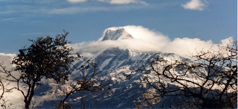
Machhapuchure Foothills

Introduction:
A short but rather hard trek which gets away from the crowded trails which dominate the popular routes in Annapurna area, offers a quick climb to altitude, rhododendron forests, high grazing pastures possibly the finest view of all for the Annapurna massif, contrasted with the quiet beauty of the low lying Seti Valley and river gorge.
Day 01 MARDI PUL (3440'/1050m):
A short drive up through the length of Pokhara town leads to the Shining Hospital at the northern end. The trek starts out up the busy trail to Hyangjo, past the new irrigation project. Here will be met fellow trekkers, local people traveling in and out to Pokhara, pony trains heading to or from Mustang, and old jeeps on the rough road to Suikhet at the top end of the Yamdi Khola valley. 15 minutes after passing the original Tibetan Refugee Camp the trail to Mardi Pul leads right across paddy fields following the west bank of the Seti Khola. After passing the confluence of the Mardi and Seti rivers the trail drops down to the river and a small bridge leads across to the village. There is an excellent campsite on the west bank of the river just above the bridge. Time 3 hours.
Day 02 ODANE HILL (8232'/2510m):
The trail follows the east bank of the Mardi upstream before turning right up the hill to the Gurung village of Riban. Due to the shortage of water higher up an early lunch is advisable. Afterwards be prepared for a hard but rewarding afternoon. The trail climbs away from the village to a Chautara (resting place) and a few minutes above divides. The right fork leads up to a few cowsheds. After being steep the trail now becomes even steeper as it climbs through bamboo towards a massive dominating slab of gray rock face. Then it bears round left on to the ridge and into rhododendron country. However the ridgeline offers little respite but compensates with the ever-developing views of the surrounding country. Through a small clearing on a high point of the ridgeline – Odane Hill 5000'/1524m higher than the start point for the day. Time 7 ½ hours.
Day 03 KUMAI (10,000'/3049m):
The trail follows the ridgeline but beware of the odd false trail than can deceive and lead the unsuspecting off the route! The previous day's work is rewarded with cool mountain air and stunning views of Macahpuchare (22,950') straight ahead of Annapurna I (26,495') to the west, towering over Annapurna South (23, 527') with its ridgeline leading to Hiunchuli (20,782'), one of the most difficult trekking peaks. To the east lies the massive granite peak of Annapurna II (26,033'), knob shape of Annapurna IV (24, 682') and the elephant like hulk of the Lamjung Himal (22, 914'), farther east the Manaslu range with Manaslu I (26,751') lying to the north of Peak 29 and the more prominent shape of Himalchuli (24, 731') and Baudha Himal (21, 884'). Given that it is also possible to get the glimpse of the summit of Dhaulagiri (26,787') away to the northwest, this means that three of the world's 14 peaks over 26, 240' or 8000m are in view. Water is in short supply and normally a packed lunch will be eaten along the way. A short sharp climb leaves the main forest behind and leads to a fine camping area in alpine grassland country. Time 6 ½ hours.
Day 04 KUMAI:
About 1 ½ hours above camp lies the high grazing country called Khorchon at aound 12,000'/3658m, and an early morning trip up to explore the area is well worthwhile. Watch out for Danfe pheasants – the National bird of Nepal and other wildlife in the area. Most might welcome an afternoon's rest back in camp but the more ambitious could explore the high country leading up towards the beautiful south face of Machapuchare and the 'trekking peak' of Mardi Himal (18,318') rising out of the southwest ridge of Machapuchare.
Day 05 GHACHOK (3500'/1067m):
Most of the altitude gained is lost during the return back down the ridge and the descent to the valley floor that follows. Just before reaching Odane Hill a little path off the east flank of the ridgeline leads to a rapid descent to grazing land and a good lunch spot at Hile. Afterwards a steep descent leads to the prosperous farming village of Chachok lying in the Seti river valley. Time 7 ½ hours.
Day 06 CHYANGLUNG HILL (6000'/1829m):
The Seti river craves an outstanding gorge through the valley and the walk north on the west bank high above the river is a delightful contrast with all that has gone before. The little bridge of Diprang is reached after about 1-½ hours and there are hot springs in the area. The climb to Chyanglung Hill is pleasant and from the very lovely setting of the campsite there are views of the Annapurna Range, whilst being very different from those seen earlier are equally as fine in their way. Time 6 hours.
Day 07 POKHARA (2994'/913m):
Back down through the forest. Ghachok village on the opposite bank of the river is passed after about 3 hours. The walk back into Pokhara inevitably brings people and building, roads, vehicles a rather sudden cultural shock after the peace and tranquility of the previous six days. Transport meets at the top end of the town to return to Pokhara – where the trek ends.


