Mustang - The Hidden Kingdom Trek
Geographical Background:
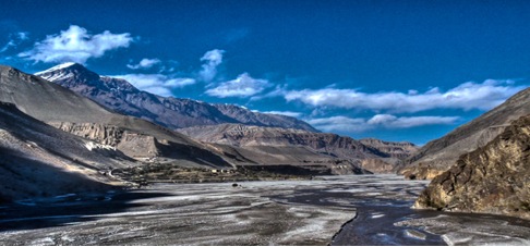
Situated on the upper reaches of the Kali Gandaki River beyond the Annapurna and the Dhaulagiri ranges, Mustang is 2,350 sq. km. in size and at an altitude ranging from 3000 – 6000 m. The population is approximately 5000, distributed in over 30 villages located along the banks or streams where irrigation is possible for agriculture. The country is extremely arid and barren, characterized by bare hills and valleys speckled with sparse vegetation (shrubs, willows and polars). Essentially a trans-himalayan region within the rain shadow behind the Himalayan range, there is very little rain which mostly falls during the summer months when the villages and their fields appear like green oasis in the characteristic Mustang windswept wilderness of rocks and dry, brown/red earth. Another typical feature of this area is the high winds that blow daily from 10 a.m. continuing until sunset. This is due to the convectional activity caused by the heating of the Tibetan Plateau resulting in low pressure, which is filled by the cooler air, which sweeps in from the high-pressure belt to the South. The wind brings with it the fine gritty sand, which gets into everything.
The chief crops grown here are barely, buckwheat, potatoes, maize, mustard and some fruit like apricots and apples. This is possible through intricate and efficient irrigation systems whereby snow melt mountain streams are diverted via canals to a communal reservoir located above the village and distributed to various field holdings as required.
Historical Background:
The history of Mustang dates back to the 8th century during the reign of the powerful religious King Detsen of Tibet. The Buddhist doctrine was spread during this period and according to the "Molla", a local historical document which traces the lineage of the Kings of Mustang, relates the advent of Buddhism and the subsequent historical developments of Mustang. A much later descendant of Trison Detsen migrated to Mustang and lived there. One of his sons, Ame Pal, rose to be a powerful Lord and defeated the local chieftains in the dzongs (castles) that dominated Mustang. Even today, the ruins of Ketcher Dzong (which belonged to Ame pal) can be seen on the high ridges overlooking Lo Manthang.
The walled city of Lo Manthang was later built by Ame Pal as his capital city after he had conquered the forts in his region and unified the country during the middle of the 15th century. The living wall, which is 2,472 feet long and 26 feet high, has a series of 14 towers along its periphery. These towers rise 40 feet high, 6 feet wide at their base and 3 feet wide at the top.
Because of its easy accessibility to the South from the Tibetan Plateau, Mustang acquired a strategic importance and developed into a major trade route between Tibet and Nepal and India. Ngorchen Kunga Sangpo, the great Sakya Lama from the Ngor Monastery in central Tibet was invited to Mustang and he initiated a religious revival in the country, establishing many monasteries and temples of the Sakya sect.
Over the centuries Mustang weathered many internal feuds and attacks from neighboring kingdoms, its main threat coming from the powerful Jumla Kingdom to the West. Throughout the sixteenth, seventeenth and eighteenth centuries Mustang had difficult relations with the Kings of Jumla to which it eventually succumbed in the mid eighteenth century, as a result of which it had to pay an annual tribute. However the Kings of Jumla were themselves conquered by the Gorkha King Prithivi Narayan Shah. From this time onwards Mustang transferred its tribute to the Gorkha Kings and thus became a subject of Nepal. In 1946 the Kingdom of Mustang was formally annexed to the unified modern state of Nepal.
Culture, Religion and Livelihood:
About 1100 Lobas people of Lo lived in the 180 mud houses of the walled city and surprisingly they observe a form of caste hierarchy. This may be the reason why it is mainly the Kuduk (Bista-the nobility and royalty of Lo) and the Phalwa (Gurung) who lived within the walled city. Gara (black smith), Shemba (butcher) and Emeta (musician) mostly live in the settlement beside the Lo-Manthang River that flows to the East of the city. The Raja and Rani of Mustang live in "Monkhar" the four storied, white washed palace located in the middle of the town. The palace was believed to be built by the first King of Mustang Ame Pal. The present Raja is his twenty second descendent. From the landscape to the language, the people, monasteries, ruined forts, everything is predominantly Tibetan in character and appearance. The stark Tibetan Plateau-like region, the Buddhist gompas, the local Tibetan dialect and dress, the salt and butter tea the inhabitants drink and the barely crops all serve as strong reminders of its close affinity to Tibet.
Buddhism is the main religion practiced in this region. The monasteries, except for a few of the Nyngma and Kargyupa sect, are all of the Sakya (Ngorpa) sect.
The people generally have three activities - in the spring they plough and sow the fields; in the summer months they live in the tents in the high grazing grounds of their horses, goats and mules; in the winter when its too cold to plough the fields or graze animals they go on trading trips to Kathmandu and India. In India they go as far as Vanaras and Assam selling sweaters. Some even venture farther afield to the cities of Bangkok, Singapore and Hong Kong during extended business trips.
The Community is based on a feudal system with class grading ranging from the King and the nobility to the lower classes such as the blacksmiths and the butchers, in a similar pattern as it used to be in Tibet. Polyandry is also practiced, and the family is closely knit reflecting the necessity to remain together to ensure survival in this harsh and beautiful land.
Wildlife:
No proper study of wildlife in this region has been made. Generally birds like lark, finch, raven, the bearded vulture and the Himalayan griffin can be seen. Wildlife is more abundant in the higher reaches in the Damodar Kund area at the base of pilgrimage for Hindus and Buddhists alike during the summer months. Blue Sheep, Argali (Marco Polo sheep), Himalayan wolves and the elusive Snow Leopard are found in this Damodar Kund region. Locals also claim to have encountered occasionally the Meti (local term for Abominable Snowman)!!
Itinerary
Day 01 Arrival in Kathmandu.
We are greeted at the airport by our local partner and get on the flight to Pokhara for. Transfer to hotel.
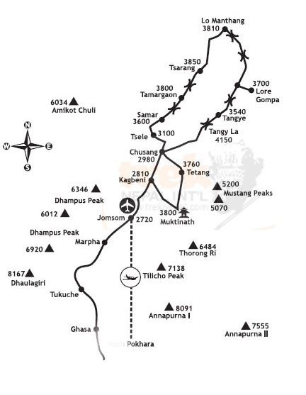
Day 02 Pokhara - Jomsom and Kagbeni (2810 m).
A small plane carrying us to the mountains in the morning. We fly low across the Kali Gandaki, the world's deepest valley, and 8000 meters high mountains on both sides. The view is magnificent; Machapuchare, Annapurnamassivet and Nilgiri to the right. To the left rises colossus Dhaulagiri 8167moh into the air. We land on the airstrip in Jhomsom 2700 meters, the administrative center of Mustang district. So far, but no longer, we may, using modern means of transport. From now on, only their own feet and any horse that can bring us further. In Eklibhatti, ca. 11 / 2 hour walk from Jhomsom, we eat lunch. Early in the afternoon we arrived in Kagbeni where we have our first camp.
Day 03 Kagbeni (2810 m) - Chusang (2963 m).
As far as the Kagbeni tourists have been allowed earlier. The narrow alleys and tunnels, irrigation canals and the large, red gompaen gives us a foretaste of what we have in store. Police checks that we have permission to enter the Upper Mustang. We stop in the village Tangbe to rest and eat lunch. Chusang lies like a green oasis beside the river, and here we turn up camp for the night. The rest of the day strolling around and we talk to the locals.
Day 04 Chusang (2963 m) - Samar (3290 m).
It's ascension to the village Chela. The culture is changing and becoming more Tibetan. We continue our ascent to the pass at about 3550m.oh The trail is wide and nice, and it is easy to walk. Height, we have noticed in that breath go a little heavier. From passport goes gradually down until we get to Samar on 3290 meters above sea level which is the current terminus. Samar is an important stopover for horse caravans.
Day 05 Samar (3290 m) - Giling (3600 m).
We put the high mountains behind us and move us in the open, dry and windswept landscape. From Samar goes up, we'll pass over two days, both approx. 3800 m before it again goes down to Giling of 3600 meters. Mustangiene is riding people. Increasingly, we meet men and women with braids and turquoise in their ears.
Day 06 Giling (3600 m) - Tram (3824 m).
The day starts with a long ascent to La Nya at 3950 meters. A little heavy it is, but on top you get rewarded. The view of Nilgiri, Tilicho Peak and Annapurna massif surpasses most. We continue over Ghemi La 3964 m before we stop for lunch in the village Ghemi. The stretch from here until the camp Tram is one of the best on the tour. The campsite is beautifully situated on the river outside the village.
Day 07 The Tram (3824 m) - Tsarang.
We continue through the valley of the incredibly exciting rock formations. Promote the Ghar Gompa we will have lunch, rest, and look us in the old monastery. Gompaen is decorated with paintings, statues and several large prayer wheels. The "tax", hundreds of carved and painted stones that are framed and exhibited on the walls. Ghar Gompa is one of the oldest still in use in Nepal.
Day 08 Tsarang - Lo Manthang (3700 m).
Today is our last leg towards the final goal and the turning point of the trip, Lo Manthang. With the high wall that surrounds the city, the king's palace, white and red temples, seems Lo Manthang large and impressive compared to the small villages we passed on the road. Behind the walls teem with life. Photo images are numerous and exotic. The networks are in Lo magic with the incessant sound of hundreds of horse bells.
Day 09 Lo Manthang (3700 m) - Horseback riding.
We rent horses and go on day trips to some of the villages north of Lo Manthang. There are several old and interesting monasteries and gompaer. We eat food for our packages and enjoy the scenery and folk life around us.
Day 10 Lo Manthang.
We use the day to visit temples and explore the city. Gompaene in Lo's from 1914 to 1500's and contains priceless cultural treasures. Chyodi Gompa is the only school in the monastery of Lo. Champa Lha - Kang and Tugchen Lha - Khang, with its art treasures are just the temples and shrines.
Day 11 Lo Manthang - Dri
We turn back and leave Lo Manthang. Back we have chosen a different route that takes us through interesting villages on the east side of the Kali Gandaki. These are areas that are rarely or never get visits from the outside world. We go first in the flat and easy terrain. Since we have a steep, wild and exciting descent to Dri that is as warm to the Kali Gandaki that they manage to get two crops a year.
Day 12 Dri - Tange.
In majestic surroundings, we follow the river a piece. After a while we leave the river and embarking on a long ascent. As always, the view from the top fantastic. Tange proves to be an idyllic oasis on the river bank.
Day 13 Tange - Pa (4060 m).
During the day when the tour's highest point, Pa at 4060 m above sea level where we camp just below the pass. Here is the only source of water between Tange and Tetang. The shepherds come with large goat herds that drinking your fill at one source that is reserved for animals. Do not include wash water today!
Day 14 Pa - Tetang.
Today it down, Tetang, located on a tributary of the Kali Gandaki.
Day 15 Tetang - Muktinath.
A long day of Tapla at 3993 meters to Muktinath. It feels like being back in civilization, even though we are one week from the nearest road. Here, the restaurants and guest houses in a row.
Day 16 Muktinath - Jomsom.
In the Hindu mythology, Mahabharata, written around 300 BC. Muktinath is mentioned. Hindu and Buddhist pilgrims have flocked here for centuries. Water is important in Hindu rituals and both Hindus and Buddhists Muktinath going to swim. We eat lunch in Eklibhatti and have our last camp in Jhomsom. Tonight is the farewell party with our Nepalese friends.
Day 17 Jomsom - Pokhara - Kathmandu.
The morning flight to Pokhara and then by plane to Kathmandu. Transfer to our hotel. The rest of the day at leisure.
Day 18 Kathmandu.
Reserve Days (in case of flight delays) at leisure in Kathmandu.
Day 19 Kathmandu.
Reserve Days (in case of flight delays) at leisure in Kathmandu.
Day 20 Kathmandu.
Sightseeing to Bhaktapur, the third largest city in the Kathmandu valley with most of the original architecture intact. Bhaktapur was the capital of the 1400-1600 figure. By Bagmatielven, 5 km from Kathmandu, is Pashupatinath, which is a pilgrimage place for Hindus. Shiva Temple here is the most important Hindu temple in Nepal. King of Nepal come here every time he going to travel to get the blessing. From Pashupatinath we go on to Boudanath where Buddhists gather. Here is the largest stupa in Nepal, it is actually one of the largest in the world. Boudanath is the religious center for Tibetans living in Nepal. The rest of the day and evening at leisure.
Day 21 Kathmandu - Pokhara.
Day on their own in Kathmandu
Day 22 Kathmandu Transfer to airport for departure.


