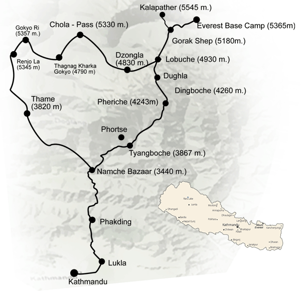
Gokyo Lake - Cho La Crossing - Kalapathar
Day 01 CHUMOA (9000'/2743m):
The flight from Kathmandu to Lukla has to be one of the most spectacular in the world. Twin Otters / Don Air fly this route of contrasting country with the snowline of the Himalayan range to the north and with the rugged foothills of Nepal below and stretching away to the south. The landing at Lukla airstrip (9184'/2880m) adds considerably to the general excitement and expectation. After a sort out and a cup of tea the trail leads northwest and descends to the river at Phakding (8698'/2652m).
Note :
On 5 August 1985 as avalanche of ice and rock falling into and ice lake above the village of Thame caused the lake to burst. The resulting flood greatly affected the Bhote Koshi Valley destroying bridges and the partially built hydro scheme below Thame. It also destroyed all the other bridges and some of the route down the Dudh Koshi. HowevIt It is worth progressing on along the new route to the attractive fir forested areas near the entrance to the Sagarmatha (Everest) National Park where there are good campsites to be found around Chumoa and Jorsale and Lodges. Time 5 ½ hours.
Day 02 NAMCHE (11300'/3440m):
Another good reason for the longish first day is that the steep hill to Namche is better done when fresh and fit in the early morning. Near the halfway point up the hill views of Everest (29028'/8848m) and Lhotse (27916'/8516m) come into sight. This prosperous town is the largest in Khumbu. A traditional trading center the Bazaar is held every Saturday. The wares on display include grains and vegetables, tennis shoes and trinkets as well as hand woven aprons and Tibetan boots. Thamserku (21728'/6623m) and Kongde (20298'/6187m) loom to the east and west, and the sacred mountain Khumbila (18729'/5707m) dominates the skyline behind the village. Time 6 hours.
Day 03 THAME (12467'/3820m):
Traverse westwards with views of Kongde and the waterfalls cascading off its flanks. Follow Bhote Koshi as trailside hills on its bank through yellow and white rhododendron forest (in full bloom in May). Cross-river, look back down valley for beautiful views of Thamserku and Kusum Kanguru (20896'/6370m). Climb up through rhododendron forest to pasture lands in front of Thame. This is the home of Tenzing Norgey, the first Sherpa ever to climb Mt. Everest. Camp in meadows at edge of village. An hour's climb to the Cliffside monastery is of great interest. From here, the trekkers can side hill above the village, then climb across the ridge to view the route to the Nangpa La, a pass to Tibet frequently used by the Sherpas and their Yaks during the monsoon. Time 6 hours.
Day 04 KHUNDE/KHUMJUNG (21434'/3991m):
Walk back down the valley by way of Thamo, where there is a hillside nunnery. Take the high trail, which bypasses Namche and drops into Khumjung. This village is one of the most beautiful in the Khumbu. It's symmetrically laid out stone dwelling houses the families of many famous Sherpas. The Sherpas may extend their hospitality and offer a teatime visit to one of their houses.
Day 05 DOLE (13251'/4040m):
The trail leads down past the school and Khumjung villages before dropping into rhododendron scrub forest and then towards an impregnable looking rock wall on the north side of the valley. A giant's causeway of granite steps makes an incredible route up this face before the trail emerges on high grazing ground. One hour further and there is a very charming Chorten, which poses naturally as the foreground for wonderful photos across the valley to Ama Dablam (22487'/6856m), Kangtega (22240'/6779m) and Thamserku standing high above the meadowlands of Thyangboche monastery. The trail drops quickly nearly all the way to the Dudh Koshi before leaving the route to Phortse. There is good lunch spot set amidst birch and rhododendron. Afterwards a stiff but attractive climb leads to Dole which lies on the tree line. Time 6 hours.
Day 06 FANGA (14694'/4400m):
The first hour involves steady climbing before the trail contours to Luza (14333'/4370m) – small grazing areas with potato fields and inhabited year round. After lunch, a short uphill then leads down to the Fanga valley. Time 5 ½ hours.
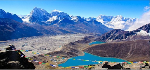
Day 07 GOKYO LAKES (15580'/4750m):
A steady climb soon leads to the first of the Gokyo Lakes and the main lake and camping. Note: Day 07 and 08 are both short days to allow additional time for acclimatization.
Day 08 GOKYO RI (17984'/5357m) and return:
Unlike the Kala Pattar hill from Lobuche the foot of Gokyo Ri lies five minutes away across a stream that feeds the lake. A two or three hour climbs leads to the summit from where the views are well worth all the effort involved. Everest showing more of its northern flank then from Kala Pattar, with Makalu (27798'/8463m) farther to the east. To the north Cho Oyu (26741'/8153m) all round snows, ice glacial moraines and the giants of the world.
Day 09 Above CHYOGIMA (16531'/5040m):
The trail initially leads back south before leaving the main route and a short climb leads to the crossing of the jumbled moraine of the Ngo Zumba Glacier. Lunch at Thagnak. Hard scrambling until a high camp tucked in below the pass is reached. Time 5 ½ hours.
Day 10 DZONGLA (15885'/4830m):
An early start is recommended and the route likes over large uncomfortable broken and scree before starting up the slab rock of the pass itself. Dependant on the time of year mixed snow and rocks leads to the summit snow field of the Chyogima La (Pass) 17777'/5330m. The descent starts gently before steeping onto rock and snow and broken ground leads to the few stone huts that make up Dzongla. Time 4 ½ hours.
Day 11 LOBUCHE (16175'/4930m):
An ill-defined track traverses across to join the main trail coming up from Pheriche. There are beautiful views of Cho Latse (21129'/6442m) back to the west. A steep ascent leads to the terminal moraine of the Khumbu Galcier. The stark and rugged beauty creates almost a moonscape. The campsite at Lobuche is tucked into a windswept side valley with a huddle of herders' huts and teahouses. Tawache and Nuptse are particularly spectacular from Lobuche. Time 4 hours.
Day 12 LOBUCHE:
Early start essential. Travel along the Khumbu Glacier through jumbled moraine and shattered rock. Climb Kala Pattar (18188'/5545m) for views of the giants of the earth. Pumori (23436'/7145m), Everest and Tibetan Peak Changtse (24764'/4501m), Nuptse, Lhotse and countless other needles and snow fluted ridges. Time 8 hours. A trip to the actual Base camp of Everest is usually omitted. The Khumbu icefall obstructs views and the base camp area is littered with debris from years of climbing expeditions to Everest, and unless an Expedition is actually at base camp a route can be difficult to find
Day 13 DINGBOCHE (14268'/4260m):
Back down the moraine and gradually losing altitude the stone windswept village of Pheriche is reached where the Himalayan Rescue Assoviation (HRA) has its Aid Post. A climb over the ridge past Chortens and Mani Walls leads to the Chukung valley and the prosperous village of Dingboche where with their own irrigation scheme they grow barley, possibly the highest altitude in the world at which this crops is grown.
Day 14 CHUKUNG (15514'/4730m):
The three or four scattered stone and slate huts provide in the summer months the base for good high grazing but during the rest of the year some of the huts are run as teahouses for trekkers. The trail from Dingboche is ill defined but follows the main line of the valley ascending gently with Ama Dablam and the high ridges leading to the difficult Amphu Lapcha Pass (18958'/5780m) on the right and massive Southern flanks of Nuptse on the left. It takes about two hours up to Chukung and an early start from Dingboche would allow plenty of time for a climb of Chukung Ri (16541'/5043m) across the mixed rubble and grassland lying just north of the houses, and from where the famous south face of Lhotse can be clearly seen. Island Peak (20299'/6189m) the most popular of the 'Trekking Peaks' stand by itself at the east end of the valley.
Day 15 TENGBOCHE (12683'/3867m):
Having been constantly at altitudes above 14000' most trekkers welcome the thought of returning to warmer, softer climbs and the days walk to Tengboche is a delightful way of doing so. Back down to Dingboche and through the long walled paths of the village, then a gradual ascent along the flanks of the hill below the village before a steep drop down to the Dudh Koshi. Above, the route rejoins the main trail coming down from Pheriche. Lunch in the meadowlands of Orsho or Shomare. Then through the important village of Pangboche (13070'/3985m) the Yeti scalp, which traveled the world in the 60s, is housed at the monastery high on the hillside here. This monastery lies more on the route to phortse and is not easily reached from the lower trail. As spectacular little bridge over the river leads into fir and rhododendron forest and a lovely afternoon's walk before the short climb to Thyangboche.
Day 16 NAMCHE:
The descent to the Imja Khola and the small village of Phunki (10660'/3250m) with its water-powered prayer wheels takes about 1 ½ hours. The original Himalayan Trust Bridge built by Sir Edmund Hillary was swept away some years ago when a flood caused by the build up of water behind a massive landslide on the flanks of Ama Dablam surged down the valley. A more temporary structure is now in place and leads to the climb up towards Khumjung. Good lunch spots are available as the gradient lessens. After lunch there is no need to return to Namche via Khumjung as a path around the eastern flanks of the hills offers easy and delightful walking back to Namche.
Day 17 LUKLA (9184'/2800m):
Most people leave Namche and head down hill with a heavy-heart. There is something about the setting, the villages and the people of the high Khumbu hills and valleys and it is sad to leave them. A long day back through Phakding and then the deceptively long hard climb leading up to Lukla. Our campsite and house are well located and offer a good final resting spot for (hopefully) the one night stay before the early morning departure.
Day 18:
Flights to Kathmandu operate during the mornings before winds above the Dudh Koshi build up. The take-off is as spectacular as the earlier landing.


